Space image: Kilimanjaro, Tanzania

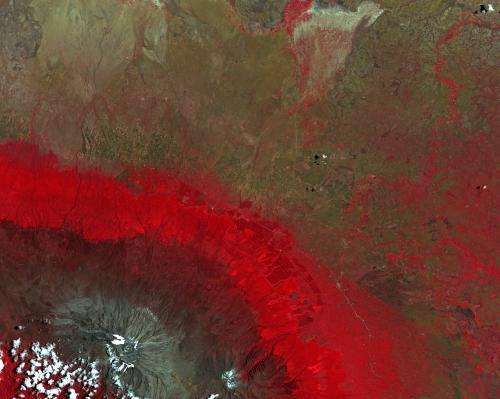
This false-colour image from Japan's ALOS satellite was acquired over part of southern Kenya and the border with Tanzania.
Mount Kilimanjaro in Tanzania can be seen in the lower-left corner. At 5895 m above sea level, this dormant volcano is Africa's highest mountain.
Kilimanjaro is a critical water catchment area for both Kenya and Tanzania, but over the past century more than 80% of its ice cover – which acts as a water storage – has disappeared. The receding ice cap together with deforestation have caused several rivers to dry up, affecting forests and farmland below.
In this image, bright red areas show the rich vegetation of the forested area on the slopes of Kilimanjaro, as well as vegetation of the agricultural areas and along rivers and streams.
False colour allows for better discrimination between different vegetation types. This is particularly helpful when satellite data are used in agricultural monitoring for mapping and classifying land use, crop type, crop health, change detection, irrigated landscape mapping and crop area mapping.
The upper section of the image is dominated by plains in southern Kenya. Nearby are a number of national parks (not shown) that attract tourists looking to see the wildlife. Animals found in this area include elephants, cape buffalo, lion, giraffe, zebra and wildebeest, among many others.
This image, also featured in the Earth from Space video programme, was acquired on 20 March 2009.
Provided by European Space Agency


