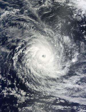
NASA's Terra satellite captured this visible image of Tropical Cyclone Bruce in the Southern Indian Ocean on Dec. 20 at 04:30 UTC. Credit: NASA Goddard MODIS Rapid Response
Tropical Cyclone Bruce continued to strengthen over wide open waters of the Southern Indian Ocean and NASA satellite data showed its eye had cleared of clouds. Bruce is forecast to stay away from land areas and weaken over the next four days.
The Moderate Resolution Imaging Spectroradiometer or MODIS instrument that flies aboard NASA's Terra satellite captured a visible image of a more wide-eyed Tropical Cyclone Bruce on Dec. 20 at 04:30 UTC. In the satellite image, the ocean surface was visible in the center of Bruce's 25 nautical-mile/28.7 mile/46.3 km-wide eye.
As of 1500 UTC/10 a.m. EST on Dec. 20, Bruce had rapidly intensified by 35 knots/40.2 mph/64.8 kph over the previous 24 hours and an astonishing 70 knots/80 mph/129.6 kph over the previous 48 hours.
Tropical cyclone Bruce had maximum sustained winds near 125 knots/143.8 mph/231.5 kph on Dec. 20 at 1500 UTC/10 a.m. EST. That makes Bruce equivalent to a Category 4 hurricane on the Saffir-Simpson Scale. Bruce was creating very rough seas, generating waves as high as 30 feet/9.1 meters. Bruce was centered about 505 nautical miles/581.1 miles/935.3 km west-southwest of Cocos Island, Australia near 13.8 south latitude and 87.5 east longitude. Bruce is moving to the west-southwest at 9 knots/10.3 mph/16.6 kph.
Forecasters at the Joint Typhoon Warning Center described Bruce's structure from animated multispectral satellite imagery as a "classic tropical cyclone structure with a deeply convective, symmetric eyewall surrounded by spiraling feeder bands in all quadrants."
In two days an approaching mid-latitude shortwave trough (elongated area) of low pressure moving in from the southwest will cause Bruce to curve to the southeast. The Joint Typhoon Warning Center expects Bruce to become extra-tropical after three of four days.
Provided by NASA's Goddard Space Flight Center


