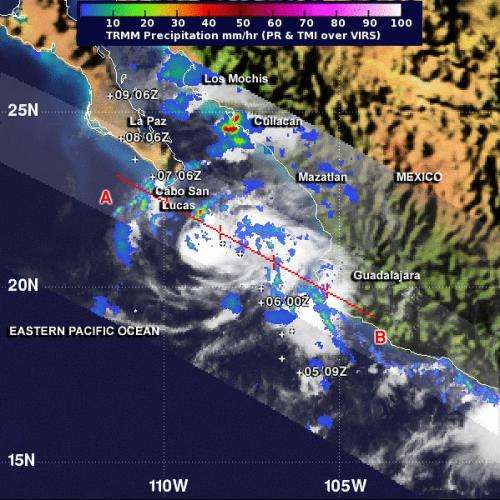
NASA's TRMM Satellite passed over Tropical Storm Lorena at 4:24 a.m. EDT and saw heaviest rain (red) falling at a rate of 2 inches/50 mm per hour near Culiacan along Mexico's west coast and over open waters just south of Cabo San Lucas on the Baja peninsula. Credit: NASA/SSAI, Hal Pierce
NASA's Tropical Rainfall Measuring Mission satellite known as TRMM passed over Tropical Storm Lorena from its orbit in space on Friday, Sept. 6 and measured the rate in which rain is falling from the storm. Lorena was soaking some areas of Mexico's west coast and is headed for landfall in Baja California, Mexico.
On Friday, Sept. 6, a tropical storm warning was in effect for Baja California Sur from Agua Blanca to Buenavista, and a tropical storm watch was in effect for Baja California Sur North of Agua Blanca to Santa Fe.
Tropical Depression 12E intensified into Tropical Storm Lorena at 5 p.m. EDT on Thursday, Sept. 5 when it was about 150 miles/245 km west of Manzanillo, Mexico.
By early Sept. 6, although Lorena's center was south of the southern tip of Baja California, its eastern quadrant was dropping heavy rainfall along the coast when NASA's TRMM Satellite passed overhead at 08:24 UTC/4:24 a.m. EDT. TRMM saw heaviest rain falling at a rate of 2 inches/50 mm per hour near Culiacan along Mexico's west coast and over open waters just south of Cabo San Lucas on the Baja peninsula. TRMM data also showed that some of the thunderstorms around Lorena's center were over 9.3 miles/15 km high, indicating high, powerful thunderstorms.
Lorena's heavy rains are expected to total between 3 and 6 inches/76 to 152 mm over the southern portion of the Baja California Peninsula with isolated maximum amounts of 10 inches/254 mm possible. The National Hurricane Center or NHC warns that these rains could produce life-threatening flash floods and mud slides. NHC noted that tropical storm force winds are expected to begin in the warning area later this morning and could continue through Saturday, Sept. 7 and tropical storm force winds are possible in the watch area that day as well.
On Sept. 6 at 8 a.m. EDT/1200 UTC, Lorena's maximum sustained winds were near 40 mph/65 kph. The NHC noted that the center of Tropical Storm Lorena was located by radar from Cabo San Lucas near latitude 21.9 north and longitude 108.9 west, just 95 miles/155 km southeast of that city. Lorena is moving toward the northwest near 14 mph/22 kph and is expected to continue toward in that direction over the next couple of days.
This weekend (Sept. 7 and 8), Lorena's center is expected to make a brief landfall near Cabo San Lucas at the southern tip of Baja California, Mexico, then briefly move over the Eastern Pacific. Lorena is expected to make a second landfall southeast of Cuidad Constitucion and move north over the Baja in the next two days while weakening.
Provided by NASA's Goddard Space Flight Center


