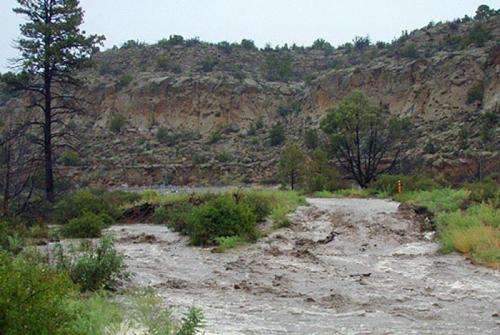
Los Alamos National Laboratory describes storm damage to environmental monitoring stations, canyons

Hours after a disaster declaration by Los Alamos County, Los Alamos National Laboratory officials on Friday described "millions" of dollars in damage to environmental monitoring stations, monitoring wells, access roads and badly eroded canyon bottoms.
"Last week we experienced an epic event," said Dave McInroy, the laboratory's program director for environmental corrective actions. "We received more than 7-and-a-half inches of rain in a four-day period and more than an inch-and-a-half in one hour on Sept. 13th. None of our recorded history has shown anything like this."
The average precipitation for a full year in Los Alamos is about 14 inches. Although Lab facilities on mesa tops suffered relatively little damage, canyons on Lab property received large, damaging floods.
In a briefing for reporters, McInroy said torrential flooding in canyons
- Damaged 75% of the Lab's canyon access roads
- Wiped out a number of the Lab's 200-plus automated stormwater samplers – field crews are still totaling the numbers on foot or all-terrain vehicle because access roads are impassible, and
- Re-routed stream channels that eroded into infrastructure, including monitoring wells.
At its peak, the estimated water flow coming from three canyons that cross the Laboratory combined to eclipse the flow rate of the nearby Rio Grande.
Three monitoring stations which support the Santa Fe public water utility were damaged last Friday and two have been returned to service.
"When you look at what happened to those two stations last Friday, to have them back up and running today is outstanding," said Pete Maggiore, manager of the Environmental Projects Office for the Department of Energy's Los Alamos Field Office.
In other cases, the force of the water bent steel and broke chains anchoring the samplers to concrete in the canyon bottoms.
Although the stormwater moved a large amount of sediment down previously cleaned-up canyons, McInroy said risk to the environment or people is extremely low. He credited the Lab's four grade-control structures, built across canyon bottoms, with trapping sediment, maintaining stability in key portions of canyons and reducing the force of the water moving downstream.
For years, sampling has shown no health risks due to floods and associated sediment in the canyons.
Lab experts will be working in the coming weeks to collect samples of sediment deposits and further assess potential changes to the conditions prior to the floods. All sample results will be posted to the public Intellus New Mexico database.
McInroy said the Lab has filed documents with the New Mexico Environment Department and the EPA notifying the agencies of an interruption in the Lab's required monitoring work. Assessments in the coming days and weeks will determine when that work can resume.
Provided by Los Alamos National Laboratory


