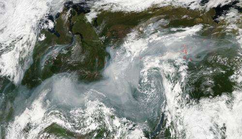
The Moderate Resolution Imaging Spectroradiometer on NASA's Aqua satellite detected dozens of fires burning in eastern Russia in this satellite image captured on August 15, 2013. The fires are outlined in red. Smoke appears as grayish, wispy air currents. Credit: NASA image courtesy Jeff Schmaltz LANCE/EOSDIS MODIS Rapid Response Team, GSFC.
The Moderate Resolution Imaging Spectroradiometer (MODIS) on NASA's Aqua satellite detected dozens of fires burning in eastern Russia in this satellite image captured on August 15, 2013. The fires are outlined in red. Smoke appears as grayish, wispy air currents.
The location, widespread nature, and number of fires suggest that these fires were deliberately set to manage land. Farmers often use fire to return nutrients to the soil and to clear the ground of unwanted plants. While fire helps enhance crops and grasses for pasture, the fires also produce smoke that degrades air quality.
According to NOVA Online, "The largest area of forests in the European region, spanning eleven time zones, is Russia. Approximately 95 percent of Russian forests lie in the boreal zone, as in Canada, and Russia's fire seasons closely resemble Canada's, with most burning occurring in late summer. A majority of Russia's boreal forests are remote and contain large amounts of accumulated fuel matter. Unmanaged fires burn freely during the fire season. Agricultural burning occurs in pockets of the Russian Federation, and many of these human-set fires quickly become uncontrolled wildfires. In recent years, fire-management teams in Russia have begun to assess ways to limit uncontrolled fires in the boreal forests, for they are a major source of carbon emissions; the carbon stored in these boreal forests accounts for approximately 37 percent of the total global carbon pool. "
Provided by NASA's Goddard Space Flight Center


