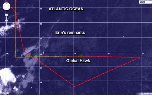
This infrared image from NOAA's GOES-East satellite on Aug. 20 shows the Global Hawk crossing the low-level remnants of Erin. Erin's low-level clouds appear as a faint circulation. The green path is the direction the Global Hawk came from. The red line represents the path the aircraft would follow. Credit: NASA/NOAA
One of two of NASA's Global Hawk unmanned aircraft flew over the remnants of Tropical Storm Erin and investigated the Saharan Air Layer in the Eastern Atlantic Ocean on Aug. 20 and 21. The instruments aboard the Global Hawk sampled the environment of ex-Erin and revealed an elevated dust layer overrunning the storm.
"Our goal with this flight was to look at how the Saharan air would move around or into the former storm, but the circulation was so shallow and weak that, according to our instruments, the Saharan air simply moved westward right over what was left of Erin," said Scott A. Braun, HS3 principal investigator and a research meteorologist at NASA's Goddard Space Flight Center in Greenbelt, Md.
Two Global Hawks are flying as part of HS3, short for NASA's Hurricane and Severe Storm Sentinel mission, this year out of NASA's Wallops Flight Facility at Wallops Island, Va. Global Hawk aircraft are well-suited for hurricane investigations because they can fly for as long as 28 hours and over-fly hurricanes at altitudes greater than 60,000 feet (18.3 km).
One of the purposes of the HS3 mission is to address the controversial role of the Saharan Air Layer in tropical storm formation and intensification. On its first flight out of Wallops, a Global Hawk obtained data about the SAL using several instruments aboard.
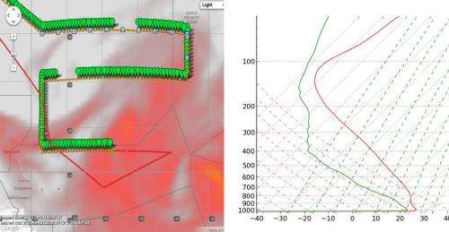
The Global Hawk track is overlaid on the GEOS-5 dust forecast (red shading). Green symbols show the locations of real-time S-HIS temperature and dew point temperature retrievals (right image, from the location of the plane symbol in the left image) which shows very dry air over the remnants of Erin. Credit: NASA
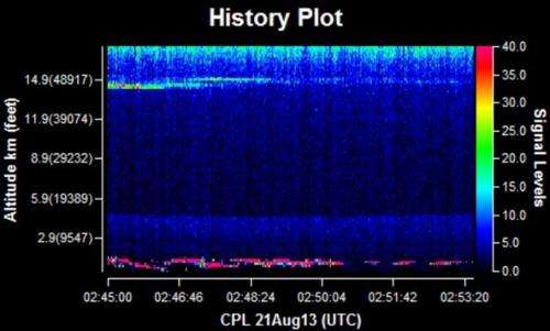
The Cloud Physics Lidar, or CPL, instrument analyzed the SAL and showed an elevated dust layer between about 1.5 and 2.8 miles (2.5 and 4.5 km) overrunning the remnants of Erin. The low-level clouds associated with what was left of Erin were located below 1.2 miles (2 km).
The CPL is an airborne lidar system designed specifically for studying clouds and aerosols. CPL will study cloud- and dust-layer boundaries and will provide optical depth or thickness of aerosols and clouds.
Another instrument aboard the Global Hawk measured temperature and dewpoint. "The scanning High-resolution Interferometer Sounder showed very dry air over the remnants of Erin," Braun said.
The Global Hawk is expected to make another trip to analyze the Saharan Air Layer on Aug. 24-25.
The Global Hawk's Cloud Physics Lidar analyzed the Saharan Air Layer and showed an elevated dust layer (dark blue shading between 1.5 to 2.8 miles). The red shading beneath shows low-level clouds associated with Erin's remnants. Lighter shading near 9.3 miles are thin cirrus clouds. Credit: NASA
HS3 is a mission that brings together several NASA centers with federal and university partners to investigate the processes that underlie hurricane formation and intensity change in the Atlantic Ocean basin. Among those factors, HS3 will address the controversial role of the hot, dry and dusty Saharan Air Layer in tropical storm formation and intensification and the extent to which deep convection in the inner-core region of storms is a key driver of intensity change.
The HS3 mission will operate between Aug. 20 and Sept. 23. The Atlantic hurricane season runs from June 1 to Nov. 30 and usually peaks in early to mid-September.
Wallops is one of several NASA centers involved with the HS3 mission. The Earth Science Projects Office at NASA's Ames Research Center in Moffett Field, Calif., manages the project. Other participants include Goddard, NASA's Dryden Flight Research Center in Edwards, Calif., NASA's Marshall Space Flight Center in Huntsville, Ala., and NASA's Jet Propulsion Laboratory in Pasadena, Calif.
Provided by NASA's Goddard Space Flight Center


