Satellite view shows Opportunity Mars rover still hard at work 10 years on

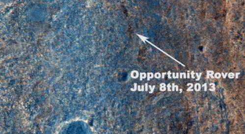
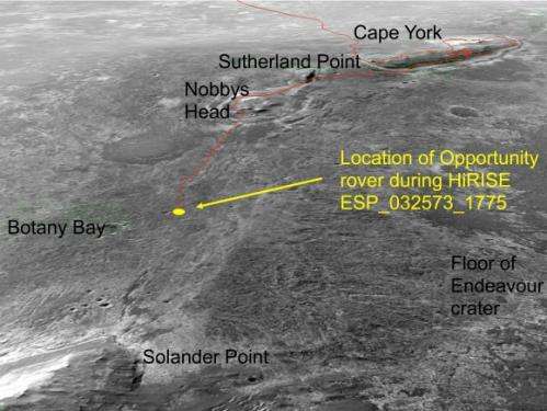
Ten years to the day after the Opportunity rover launched to Mars, the HiRISE camera on the Mars Reconnaissance Orbiter snapped this image of the rover, still toiling away on the surface of Mars. The white dot in the image is Oppy, as the rover was crossing the level ground called "Botany Bay" on its way to a rise called "Solander Point." We're looking into whether there's a way to determine if the rover was actually moving at the time the image was taken.
This, of course, is not the first time HiRISE has found the various rovers on Mars' surface. Images from orbit help rover drivers find safe routes, as well as helping to identify enticing science targets for future investigation.
"The Opportunity team particularly appreciates the color image of Solander Point because it provides substantially more information on the terrains and traverse that Opportunity will be conducting over the next phase of our exploration of the rim of Endeavour crater," said Mars Science Laboratory Project Scientist Matt Golombek, from JPL.
Opportunity currently holds the US space program's all-time record for distance traversed on another planetary body at greater than 36 kilometers or 22 miles. The Lunar Reconnaissance Orbiter team recently confirmed that the Lunokhod 2 rover traveled 42 km (26 miles) on the Moon.
Opportunity was launched from on July 7, 2003, PDT and EDT (July 8, Universal Time). Opportunity has been on the western rim of 20-kilometer-diameter Endeavour Crater in Meridiani Planum for about two years investigating the 3 to 4 billion-year-old sedimentary layers of Cape York. Now the rover is traversing south to new science targets and a winter haven at Solander Point.

Keep on truckin'!
Provided by Universe Today


