Evidence for a Martian Ocean

(Phys.org) —Researchers at the California Institute of Technology (Caltech) have discovered evidence for an ancient delta on Mars where a river might once have emptied into a vast ocean.
This ocean, if it existed, could have covered much of Mars's northern hemisphere—stretching over as much as a third of the planet.
"Scientists have long hypothesized that the northern lowlands of Mars are a dried-up ocean bottom, but no one yet has found the smoking gun," says Mike Lamb, an assistant professor of geology at Caltech and a coauthor of the paper describing the results. The paper was published online in the July 12 issue of the Journal of Geophysical Research.
Although the new findings are far from proof of the existence of an ancient ocean, they provide some of the strongest support yet, says Roman DiBiase, a postdoctoral scholar at Caltech and lead author of the paper.
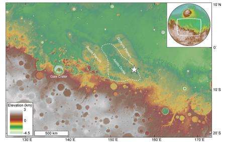
Most of the northern hemisphere of Mars is flat and at a lower elevation than the southern hemisphere, and thus appears similar to the ocean basins found on Earth. The border between the lowlands and the highlands would have been the coastline for the hypothetical ocean.
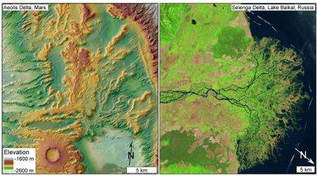
The Caltech team used new high-resolution images from the Mars Reconnaissance Orbiter (MRO) to study a 100-square-kilometer area that sits right on this possible former coastline. Previous satellite images have shown that this area—part of a larger region called Aeolis Dorsa, which is about 1,000 kilometers away from Gale Crater where the Curiosity rover is now roaming—is covered in ridge-like features called inverted channels.

These inverted channels form when coarse materials like large gravel and cobbles are carried along rivers and deposited at their bottoms, building up over time. After the river dries up, the finer material—such as smaller grains of clay, silt, and sand—around the river erodes away, leaving behind the coarser stuff. This remaining sediment appears as today's ridge-like features, tracing the former river system.
When looked at from above, the inverted channels appear to fan out, a configuration that suggests one of three possible origins: the channels could have once been a drainage system in which streams and creeks flowed down a mountain and converged to form a larger river; the water could have flowed in the other direction, creating an alluvial fan, in which a single river channel branches into multiple smaller streams and creeks; or the channels are actually part of a delta, which is similar to an alluvial fan except that the smaller streams and creeks empty into a larger body of water such as an ocean.
To figure out which of these scenarios was most likely, the researchers turned to satellite images taken by the HiRISE camera on MRO. By taking pictures from different points in its orbit, the spacecraft was able to make stereo images that have allowed scientists to determine the topography of the martian surface. The HiRISE camera can pick out features as tiny as 25 centimeters long on the surface and the topographic data can distinguish changes in elevation at a resolution of 1 meter.
Using this data, the Caltech researchers analyzed the stratigraphic layers of the inverted channels, piecing together the history of how sediments were deposited along these ancient rivers and streams. The team was able to determine the slopes of the channels back when water was still coursing through them. Such slope measurements can reveal the direction of water flow—in this case, showing that the water was spreading out instead of converging, meaning the channels were part of an alluvial fan or a delta.
But the researchers also found evidence for an abrupt increase in slope of the sedimentary beds near the downstream end of the channels. That sort of steep slope is most common when a stream empties into a large body of water—suggesting that the channels are part of a delta and not an alluvial fan.
Scientists have discovered martian deltas before, but most are inside a geological boundary, like a crater. Water therefore would have most likely flowed into a lake enclosed by such a boundary and so did not provide evidence for an ocean.
But the newly discovered delta is not inside a crater or other confining boundary, suggesting that the water likely emptied into a large body of water like an ocean. "This is probably one of the most convincing pieces of evidence of a delta in an unconfined region—and a delta points to the existence of a large body of water in the northern hemisphere of Mars," DiBiase says. This large body of water could be the ocean that has been hypothesized to have covered a third of the planet. At the very least, the researchers say, the water would have covered the entire Aerolis Dorsa region, which spans about 100,000 square kilometers.
Of course, there are still other possible explanations. It is plausible, for instance, that at one time there was a confining boundary—such as a large crater—that was later erased, Lamb adds. But that would require a rather substantial geological process and would mean that the martian surface was more geologically active than has been previously thought.
The next step, the researchers say, is to continue exploring the boundary between the southern highlands and northern lowlands—the hypothetical ocean coastline—and analyze other sedimentary deposits to see if they yield more evidence for an ocean.
"In our work and that of others—including the Curiosity rover—scientists are finding a rich sedimentary record on Mars that is revealing its past environments, which include rain, flowing water, rivers, deltas, and potentially oceans," Lamb says. "Both the ancient environments on Mars and the planet's sedimentary archive of these environments are turning out to be surprisingly Earth-like."
The title of the Journal of Geophysical Research paper is "Deltaic deposits at Aeolis Dorsa: Sedimentary evidence for a standing body of water on the northern plains of Mars."
Journal information: Journal of Geophysical Research
Provided by California Institute of Technology


