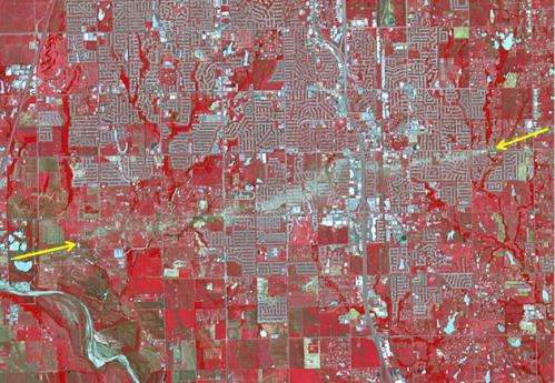
NASA spacecraft sees tornado's destructive swath

(Phys.org) —A new image from the Advanced Spaceborne Thermal Emission and Reflection Radiometer (ASTER) instrument on NASA's Terra spacecraft shows the extent of destruction from the deadly Newcastle-Moore tornado that ripped through central Oklahoma on May 20, 2013.
The Newcastle-Moore tornado was rated at EF-5 on the Enhanced Fujita scale. An EF-5 is the most powerful category of tornado.
ASTER acquired this false-color image of the scar left on the landscape by the tornado's track on June 2, 2013. In the image, vegetation appears red, water is dark blue, roads and buildings are gray, and white and bare fields are tan. The tornado's track crosses the image from left to right, as indicated by the arrows. The image covers an area of 6 by 8.6 miles (9.6 by 13.8 kilometers), and is located at 35.3 degrees north latitude, 97.5 degrees west longitude.
The Newcastle-Moore tornado had peak winds estimated at 210 mph (340 kilometers per hour). It remained on the ground for 39 minutes over a 17-mile-long path (27 kilometers). As of June 5, the storm is known to be responsible for 24 deaths and more than $2 billion in damage.
With its 14 spectral bands from the visible to the thermal infrared wavelength region and its high spatial resolution of about 50 to 300 feet (15 to 90 meters), ASTER images Earth to map and monitor the changing surface of our planet. ASTER is one of five Earth-observing instruments launched Dec. 18, 1999, on NASA's Terra spacecraft.
More information: More information about ASTER is available at asterweb.jpl.nasa.gov/ .
Provided by NASA


