(Phys.org) —As Tropical Cyclone Rusty crossed the Pilbara coast last week, the ocean's turbidity levels exceeded the maximum range of scientists' instruments.
Professor Charitha Pattiaratchi from The University of Western Australia said Rusty surprised him and his colleagues by stirring up the ocean unlike anything measured before.
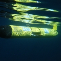
Measurements were collected from a remote-controlled underwater glider that was on its routine quarterly journey from Broome north towards Scott Reef, about 200 kilometres offshore.
"We've deployed gliders on about 150 missions over the past four to five years all around Australia," said Professor Pattiaratchi, who leads the Ocean Glider Facility of Australia's Integrated Marine Observing System (IMOS).
"None of them had turbidity levels beyond our instrument range from the surface right down to the sea floor.
"Turbidity is caused by the action of both waves and currents, and the data collected shows that the speed of the ocean currents almost doubled."
Professor Pattiaratchi said the high turbidity levels were due to sediment and organic matter being stirred up, or re-suspended, from the sea floor at 30 metres depth.
Nutrients were also stirred up from the sea floor, resulting in a bloom of microscopic plants called phytoplankton, which was evident by an increase in the chlorophyll concentrations.
The bloom is so big-about the size of Tasmania-that it can easily be seen from space, as satellite images show.
"We've not been able to collect this type of data until now," Professor Pattiaratchi said.
"Normally we take samples from a ship or a boat but it is not possible to be on board a research vessel in 125km/hour winds. The glider gives us an opportunity to collect data under extreme conditions. We couldn't have done it otherwise. Satellites provide us information on the ocean surface conditions but gliders tell us what's happening below the surface."
IMOS operates a fleet of remote-controlled underwater ocean gliders that take measurements from Australian waters. Designed to withstand extreme weather and equipped with a variety of sensors, they move horizontally through the water while collecting vertical profiles and sending the data back to base via satellite in near-real time.
Provided by University of Western Australia


