Natural disasters: Is your municipality vulnerable?

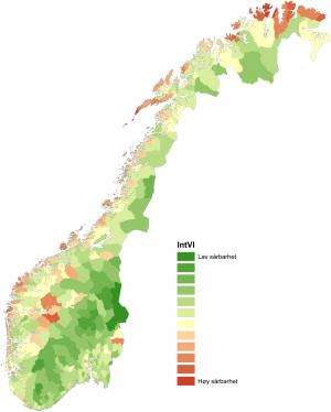
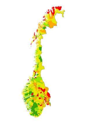
How vulnerable are municipalities to adverse effects from flooding, strong winds, avalanches, land or mudslides or other natural disasters? In Norway, researchers have developed an interactive map displaying physical and social vulnerability throughout the country.
Physical factors dictate only part of the picture of how vulnerable a community is in the event of a natural disaster. When hurricane Katrina hit New Orleans in 2005, the force of the onslaught was the same for all. Its impact, however, differed widely across the social strata. While those who owned cars were able to drive to safety, others of lesser means had no choice but to stay behind.
Demographic and social factors play a role
"Age, gender, ethnicity, income and assets all play an important role in the ability to handle crises such as natural disasters," states Professor Haakon Lein in the Department of Geography at the Norwegian University of Science and Technology (NTNU) in Trondheim.
"The groups that tend to be the hardest hit in these situations are children and the elderly, as they are less mobile than others; immigrants, because they may have weaker financial status and social networks or language difficulties; and single parents," explains Dr Lein.
Professor Lein has headed the research project "The geography of social vulnerability, environmental hazards and climate change (VULCLIM)". The project has received funding under the large-scale programme, Climate change and impacts in Norway (NORKLIMA) at the Research Council of Norway.
Physical and social conditions viewed together
Based on the knowledge that both physical and social factors play a role in a community's vulnerability to natural disasters, the researchers have created two types of interactive maps:
- a physical vulnerability index showing how vulnerable an area is to dangers that may damage life and property;
- a social vulnerability index showing the potential vulnerability of the local population if such a physical event were to occur.
"We can study the two vulnerability indices separately or together," says Dr Lein. "When we examine the two together, we gain a more integrated understanding of how vulnerable the individual community in Norway is to natural calamities such as flooding, landslides and avalanches."
If the social vulnerability within an area is high, the consequences of a disastrous event may be more severe than if the same event occurred in an area of low social vulnerability. Municipalities with low social vulnerability are often economically stable, with financially sound residents. This puts both the municipality and its residents in a better position to deal with an extreme event.

Small municipalities and large cities are vulnerable
The project shows that coastal municipalities in the north and along the western coast of Norway are among those at greatest risk. In these municipalities, the role of social vulnerability is as significant as exposure in terms of geography.
In terms of its location, Oslo is at little risk of sustaining an extreme natural event. But the city nonetheless scores rather high in overall vulnerability due to its population density and proportion of non-Western immigrants.
Aid in emergency planning and response
The maps and other visualisations that have been developed identify and explain what makes a municipality vulnerable. Thus they can be used by municipality and county officers as a valuable basis for emergency planning and other proactive measures.
The researchers are planning to continue by examining the vulnerability of the individual districts of each municipality. Efforts to design higher-detail vulnerability indices are taking place under a joint Nordic project under the Nordic Centre of Excellence on climate adaptations, NORD-STAR (Nordic Strategic Adaptation Research). The objective is to create a map that is easily accessible on the Internet.
See how it works
You can see for yourself how the interactive vulnerability map of Norway's municipalities works. Click on the link to the right for a preliminary version of the map.
Provided by The Research Council of Norway


