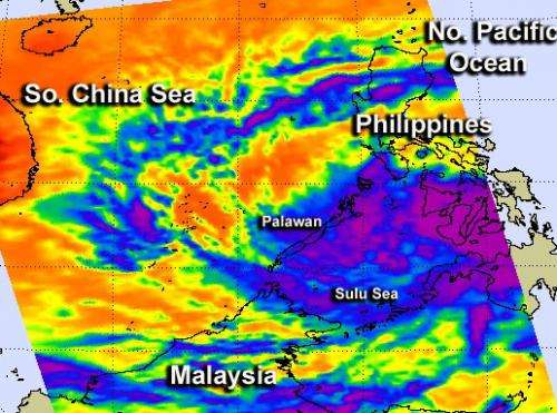
NASA's Aqua satellite passed over Tropical Depression 02W as it was coming together and soaking provinces in Mindanao and the Palawan province of Luzon. This infrared AIRS image from 12:41 a.m. EST on Feb. 19 showed strong storms (purple) over Mindanao and stretching west to Palawan. Credit: NASA JPL, Ed Olsen
The second tropical depression of the northwestern Pacific Ocean season formed on Feb. 19, and NASA's Aqua satellite showed the storm was soaking the central and southern Philippines.
NASA's Aqua satellite passed over Tropical Depression 02W (TD02W) as it was coming together and soaking provinces in Mindanao and the Palawan province of Luzon. The Atmospheric Infrared Sounder (AIRS) instrument that flies aboard Aqua captured an infrared image of the depression at 0541 UTC (12:41 a.m. EST). The AIRS image showed very cold cloud top temperatures, colder than -63F (-52C) over Mindanao and stretching west to Palawan. Cloud top temperatures that cold are indicative of the potential to drop heavy rainfall.
AIRS infrared satellite imagery showed a very poorly organized and ill- defined low-level circulation center. The convection (rising air that forms thunderstorms that make up the depression) appears disorganized in the northern quadrant of the storm.
On Feb. 19 at 0900 UTC, the low pressure area designated as System 98W organized into a tropical depression and was renamed "02W." Tropical Depression 02W formed south of Mindanao, the Philippines. TD02W is referred to locally in the Philippines as "Tropical Depression Crising."
As a result of the formation of the depression, warnings were posted by PAGASA for many areas in the Philippines. Public storm warning signal #1 was posted for the following provinces of Mindanao: Davao del Norte and Sur and Oriental, Samal Island, Compostela Valley, the southern part of Surigao del Sur, Agusan del Sur, Bukidnon, Lanao del Norte and Sur, North Cotabato, Maguindanao, Sultan Kudarat, South Cotabato, Sarangani, Misamis Occidental, Zamboanga del Norte and Sur and& Sibugay, Basilan, Sulu and Tawi-Tawi. In addition, Signal #1 is now in effect for the south of the Palawan province of Luzon.
On Feb. 19 at 1500 UTC (10 a.m. EST), TD02W had maximum sustained winds near 25 knots (28.7 mph/46.3 kph). TD02W was located near 6.5 north latitude and 122.9 east longitude, just 55 nautical miles (63.3 miles/102 km) east-southeast of Zamboanga, Philippines. RD02W is moving to the west-northwest at 9 knots (10.3 mph/16.6 kph).
TD02W is currently experiencing moderate vertical wind shear, as high as 20 knots (23 mph/37 kph) which is keeping the depression from getting better organized. That is expected to change, however, once TD02W moves west into the South China Sea.
Forecasters at the Joint Typhoon Warning Center expect TD02W to move to the west-northwest, and pass just south of Palawan's southern tip before moving into open waters of the South China Sea where it is expected to become more organized.
Provided by NASA's Goddard Space Flight Center


