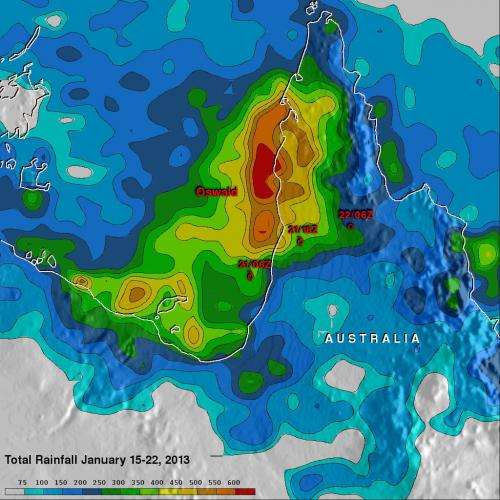
This TRMM satellite rainfall analysis covers the period from Jan. 15-22, 2013. The analysis showed that Oswald and its remnants have already dropped over 600 mm (~23.6 inches) of rain in areas of the Cape York Peninsula near the Gulf of Carpentaria. Credit: NASA/SSAI, Hal Pierce
Tropical Storm Oswald's heavy rains have caused flooding in Queensland, Australia and NASA's TRMM satellite measured almost two feet of rain fell in certain areas.
Tropical cyclone Oswald's sustained winds have never been greater than 35 knots (~40.2 mph) but the storm's extreme rainfall has resulted in widespread flooding in Australia over northern Queensland. Many roads have been reported flooded resulting in some communities being cut off.
NASA's Tropical Rainfall Measuring Mission (TRMM) is a satellite that can measure rainfall from space. TRMM-based satellite precipitation estimates are created at NASA's Goddard Space Flight Center in Greenbelt, Md. within about seven hours of observation time. Hal Pierce of NASA Goddard created a rainfall image from a Multi-satellite Precipitation Analysis (MPA) for the period from January 15 to 22, 2013. The analysis showed that Oswald and its remnants had dropped over 600 mm (~23.6 inches) of rain in areas of the Cape York Peninsula near the Gulf of Carpentaria.
According to a report on news.com.au, travelers were requested to cancel plans to go to the Cape York Peninsula, Queensland. Many rivers have flooded and dirt roads are mired in mud over a distance of 560 kilometers (348 miles) that stretch from Laura to Bamaga. Rainfall totals over the Cape York Peninsula to Cardwell were as high as 200mm (7.8 inches) to 300 mm (11.8 inches), which fell south of the town of Innisfail.
Provided by NASA's Goddard Space Flight Center


