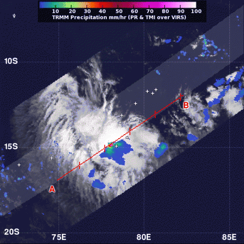
On Jan. 16 at 0702 UTC (2:02 a.m. EST) NASA's TRMM satellite saw mostly moderate rain (in green) in Tropical Storm Emang. There was one small area of heavy rainfall (red) near the center where rain was falling at 2 inches/50 mm per hour. Credit: Credit: SSAI/NASA, Hal Pierce
Tropical Storm Emang continues to move through open waters in the Southern Indian Ocean and NASA's TRMM satellite noticed one area of heavy rainfall near the center.
On Jan. 16 at 0702 UTC (2:02 a.m. EST) NASA's Tropical Rainfall Measuring Mission (TRMM) satellite passed over Emang, and captured rainfall rates. TRMM identified that moderate rain was falling throughout most of the tropical cyclone, and heavy rainfall was occurring near the storm's center. TRMM estimated the heavy rain falling at a rate of 2 inches (50 mm) per hour.
On Jan. 16 at 0900 UTC (4 a.m. EST), Tropical Storm Emang had maximum sustained winds near 35 knots (40 mph/64.8 kph). Emang was located near 14.2 south latitude and 77.7 east longitude, about 580 nautical miles (667.5 miles/1,074 km) southeast of Diego Garcia. Emang is moving slowly to the west at 3 knots (3.4 mph/5.5 kph). Emang is currently not a threat to any land areas.
Emang is expected track west-southwest and may affect La Reunion Island by Jan. 21. However, as it tracks west, after briefly intensifying, wind shear and cooler water temperatures are expected to weaken the storm.
Provided by NASA's Goddard Space Flight Center


