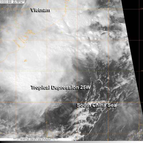
NASA's Aqua satellite passed over newborn Tropical Depression 25W on Nov. 14 at 0638 UTC (1:38 a.m. EDT) as its northern edge was bringing rains and gusty winds over southern Vietnam. Credit: NASA/NRL
The twenty-fifth tropical depression of the western North Pacific Ocean season formed today and is already affecting southern Vietnam. NASA's Aqua satellite passed over Tropical Depression 25W and captured a visible image of the storm that showed its northern quadrant raining over the country.
When NASA's Aqua satellite passed over newborn Tropical Depression 25W (TD25W) on Nov. 14 at 0638 UTC (1:38 a.m. EDT), the Moderate Resolution Imaging Spectroradiometer (MODIS) instrument captured a visible image of the storm. At the time of the image, the strongest thunderstorms appeared to be over the Long Khanh District, northwest of Vung Tau and Ho Chi Minh City.
On Nov. 14 at 1200 UTC (7 a.m. EDT) TD25W had maximum sustained winds near 25 knots (28.7 mph/46.3 kph). It was centered near 8.3 North latitude and 106.6 East longitude, about 160 nautical miles (184.1 miles/296.3 km) south of Ho Chi Minh City, Vietnam. TD25W is moving to the west-northwest at 14 knots (16.1 mph/26 kph).
TD25W is currently battling moderate wind shear, and its convection has waned during the early morning hours on Nov. 14. The depression is expected to remain loosely organized over the next couple of days. TD25W is forecast to move through the Gulf of Thailand, cross southern Thailand and move into the Andaman Sea.
Provided by NASA's Goddard Space Flight Center


