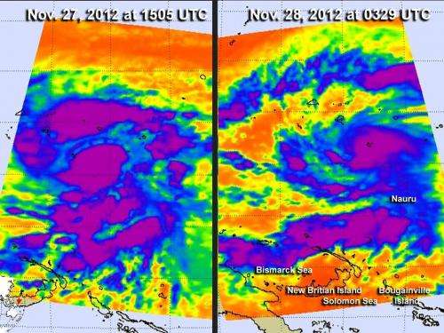
Infrared NASA imagery sees Tropical Storm Bopha grow a tail

Tropical Storm Bopha continues to intensify in the western North Pacific Ocean as it heads toward Yap State, triggering more warnings and watches. Infrared imagery from NASA's Aqua satellite captured over two days revealed that the storm had consolidated, intensified and developed a large band of strong thunderstorms south of the center, that resemble a tail.
Infrared images of Tropical Storm Bopha were taken by the AIRS instrument on NASA's Aqua satellite on Nov. 27 at 1505 UTC when Bopha had maximum sustained winds near 45 mph, and on Nov. 28 at 0329 UTC when Bopha's winds increased to 65 mph. The highest, coldest, strongest thunderstorms with heavy rainfall were tightly wrapped around Bopha's center of circulation, and in a newly developed, more organized band of strong thunderstorms south of the storm's center. That large band of thunderstorms resembles a tail to the storm that drapes from the Bismarck Sea, southwest of the storm's center, east to Nauru.
A tropical storm warning remains in effect for Lukunor and the Southern Mortlocks in Chuuk State, Puluwat in Chuuk State and Satawal in Yap State. Heavy rainfall, tropical-storm-force winds, and ocean swells between 1 and 2 feet can be expected in warning areas. The National Weather Service noted that Bopha is generating 10 to 12 foot swells near the center which will result in hazardous surf of 12 to 14 feet along eastern and southeastern and southern shores of Lukunor and nearby islands today, Nov. 28.
A typhoon watch remains in effect for Woleai in Yap state, and a tropical storm watch remains in effect for Faraulep in Yap state.
On Nov. 28, at 10 p.m. CHST local time (1300 UTC/8 a.m. EDT/U.S.), Tropical Storm Bopha's maximum sustained winds had increased to 65 mph, and the storm is moving west at 10 mph. According to the National Weather Service in Guam, "That general motion is expected to continue over the next 24 hours. Tropical Storm Bopha is expected to continue intensifying and may become a typhoon Thursday afternoon, Nov. 29."
At 7 p.m. CHST (0900 UTC/4 a.m. EDT/U.S.) the center of Tropical Storm Bopha was near latitude 5.0 degrees north and longitude 152.5 degrees east. That put the center about 135 miles west-southwest of Lukunor, 175 miles south of Weno Island, Chuuk, and 255 miles southeast of Puluwat. Tropical storm force winds extend outward up to 50 miles from the center, making the storm over 100 miles in diameter.
Provided by NASA's Goddard Space Flight Center


