NASA sees Tropical Storm Sandy approaching Jamaica

NASA satellites are closely monitoring Tropical Storm Sandy in visible and infrared light as it approaches Jamaica. Sandy is now responsible for hurricane and tropical storm warnings and watches from Jamaica to Cuba, the Bahamas and southern Florida. Sandy is expected to become a hurricane before it reaches Jamaica and Cuba.
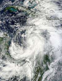
On Oct. 23, 2012 at 1545 UTC (11:45 a.m. EDT), the Moderate Resolution Imaging Spectroradiometer (MODIS) instrument captured a visible image of Tropical Storm Sandy when its center was a couple of hundred miles south of Jamaica. Sandy's clouds filled up the eastern Caribbean Sea, and showed signs of good circulation. The MODIS image revealed that Sandy's cloud cover extends over 280 miles (440 km). Tropical storm force winds extend outward up to 140 miles (220 km) from the center.

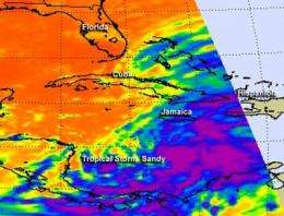
The Atmospheric Infrared Sounder (AIRS) instrument aboard NASA's Aqua satellite captured infrared imagery of Tropical Storm Sandy later that day at 2:47 p.m. EDT. The infrared image showed the strongest thunderstorms surrounded the center of circulation. Those thunderstorms are reaching high into the troposphere where cloud top temperatures are as cold as -63 Fahrenheit (-52 Celsius).
On Oct. 24, the warnings and watches posted covered a large area. A Hurricane Warning is in effect for Jamaica, the Cuban Provinces of Camaguey, Las Tunas, Granma, Santiago De Cuba, Holguin, and Guantanamo. A Tropical Storm Warning is in effect for Haiti, the Central Bahamas, and the Northwestern Bahamas.
A Tropical Storm Watch is in effect for the Southeastern Bahamas, the Florida East Coast from Jupiter Inlet to Ocean Reef, the Florida Upper Keys from Ocean Reef to Craig Key, and Florida Bay.
At 8 a.m. EDT on Oct. 24, Tropical Storm Sandy's maximum sustained winds were on the edge of hurricane-force at 70 mph (110 kph). Hurricane strength is 74 mph. Sandy's center was located near latitude 16.6 north and longitude 76.9 west, just 95 miles (155 km) south of Kingston, Jamaica. Sandy is moving toward the north near 14 mph (22 kph) and the National Hurricane Center (NHC) noted that this general motion is expected to continue through Thursday (Oct. 25) accompanied by a gradual increase in forward speed.
According to NHC forecasters, the center of Sandy is expected to move across Jamaica by late this afternoon and evening today, Oct. 24 and move near or over eastern Cuba late tonight and Thursday morning. Oct. 25. Sandy is then expected to approach the central Bahamas on Thursday.
Provided by NASA's Goddard Space Flight Center


