Satellites see Tropical Storm Nadine 'refuse to go away'

Nearly two weeks after becoming a tropical storm in the central Atlantic back on September 11th, NASA satellites confirm that Nadine is still spinning away south of the Azores as a minimal tropical storm. One of those satellites called TRMM has been providing forecasters with rainfall rates and cloud heights.
Nadine initially formed into a tropical depression from an African easterly wave that had propagated westward out into the central Atlantic from the coast of Africa. Nadine initially moved northwestward then northward before getting caught up in the westerlies over the north-central Atlantic on Sept. 15. It was there that Nadine became a minimal hurricane as it moved due east. After two days, Nadine turned to the northeast in the direction of the Azores and weakened back to a tropical storm. Nadine slowed down as it approached the Azores and became almost stationary on Sept. 20 about 150 miles (~240 km) southwest of the islands. Nadine than began moving just south of due east again then finally southward away from the islands. At this point, Nadine lost some of its tropical characteristics as convection died out around the center, and it was declared post-tropical by the National Hurricane Center. A day and a half later on Sept. 23, Nadine regained some of its thunderstorm activity and was declared a tropical storm again. By now, Nadine was well south of the Azores and beginning to move westward again.
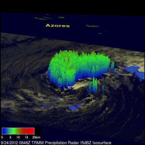
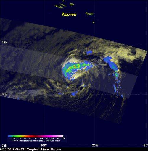
The Tropical Rainfall Measuring Mission (TRMM) satellite has been keeping tabs on Nadine in the central Atlantic. TRMM captured an image of Nadine on the morning of the September 24 after Nadine had again become a tropical storm. The image taken at 08:49 UTC (4:49 pm EDT) September 24, provided a look into the structure of Nadine by way of the storm's rain pattern.

The TRMM imagery is created at NASA's Goddard Space Flight Center in Greenbelt, Md. To make the images of rainfall, rain rates in the center of the image are created from the TRMM Precipitation Radar (PR), while those in the outer swath are from the TRMM Microwave Imager (TMI). The rain rates are then overlaid on infrared (IR) data from the TRMM Visible Infrared Scanner (VIRS).
The TRMM imagery showed that Nadine's cyclonic circulation is clearly evident in the swirling cloud elements (visible in white) as they spiral in towards the center in a counter clockwise direction. In terms of rainfall, Nadine is very asymmetric with nearly all of the rain contained in a rainband north of the center (shown in green, indicating moderate rain).Right near the center, there were some smaller areas of rain present (shown in blue, indicating light rain), but nothing significant that would indicate Nadine is preparing to intensify.
In fact, Nadine had been and continues to experience some southwesterly wind shear and dry air. Combined with marginal sea surface temperatures, it is not an environment conducive for development. However, conditions are forecast to become more favorable in a couple of days and Nadine could become a little stronger.
On Sept. 25, at 5 a.m. EDT (0900 UTC0, Nadine's maximum sustained winds were near 45 mph (75 kmh) with higher gusts. The National Hurricane Center expects some slow strengthening over the next two days. The center of Tropical Storm Nadine was located near latitude 32.1 north and longitude 29.6 west. Nadine is moving toward the west near 6 mph (9kmh) and a turn toward the southwest with a reduction in forward speed is expected later today, followed by a turn to the south on Wednesday, Sept. 26. Nadine's estimated minimum central pressure is 996 millibars.
Despite its relatively long life, Nadine has a ways to go before capturing the record. Hurricane Ginger was around for 27 days back in 1971, and the 1899 Puerto Rico Hurricane lasted 28 days as a tropical cyclone.
Provided by NASA's Goddard Space Flight Center


