NASA sees many things happening in Tropical Storm Ewiniar

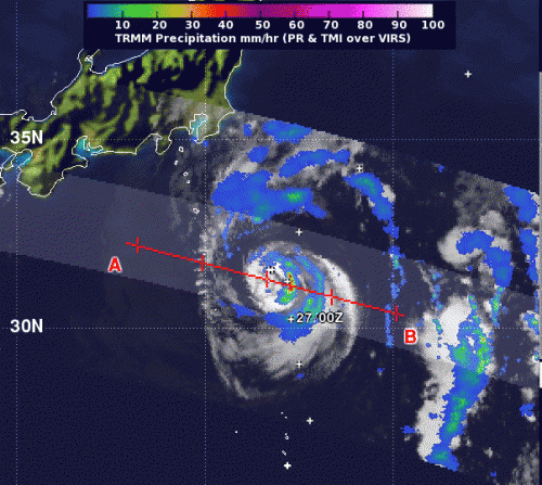
There are a number of things happening under the hood of Tropical Storm Ewiniar's clouds that have been deciphered by satellite data today, Sept. 28, 2012, and NASA's TRMM satellite has noticed one area of heavy rainfall remaining.
NASA's Tropical Rainfall Measuring Mission (TRMM) satellite noticed light to moderate rainfall around most of the tropical storm, with the heaviest rainfall east of the center of circulation. Rainfall in that area was falling at a rate of 2 inches (50 mm) per hour).
Tropical Storm Ewiniar has a partially exposed low-level circulation center, which opens the lower level of the storm to outside winds that can adversely affect it. Satellite data also revealed that there are bands of convective thunderstorms wrapping around the center from the southeast to the northern quadrant of the storm. Within that band, the strongest thunderstorms are on the eastern quadrant. In addition, microwave satellite data shows an eye feature today, Sept. 28.
As Tropical Storm Ewiniar continues to move northward it remains embedded in an elongated area of low pressure (called a trough) off Japan's east coast. The trough continues to bring strong westerly winds into Ewiniar at a rate of speed between 40 and 50 knots. Although facing this strong wind shear, Ewiniar continues to keep its tropical warm core.
On Sept. 28 at 0900 UTC (5 a.m. EDT, Tropical Storm Ewiniar's maximum sustained winds dropped from 55 knots (63.2 mph/102 kmh) to 45 knots (51.7 mph/83.3 kmh). It was located near 32.3 North and 143.5 East, about 280 nautical miles (322 miles/518.6 km) southeast of Tokyo, Japan and further away since Sept. 27. Ewiniar is moving to the east-northeast at 8 knots (9.2 mph/14.8 kmh) and is expected to turn to the northeast over the weekend of Sept. 29 and 30, and farther away from Japan.
Provided by NASA's Goddard Space Flight Center


