First mobile NASA app and QuakeSim share agency's 2012 Software Award

NASA's first mobile application and software that models the behavior of earthquake faults to improve earthquake forecasting and our understanding of earthquake processes are co-winners of NASA's 2012 Software of the Year Award. The award recognizes innovative software technologies that significantly improve the agency's exploration of space and maximize scientific discovery on Earth.
Software engineers at NASA's Ames Research Center in Moffett Field, Calif., developed the NASA App for mobile platforms including the iPhone, iPod touch, iPad and Android phones and tablets. The NASA App currently has more than 9.6 million user installations and receives more than three million hits per day on average.
The NASA App gathers the agency's online content, breaking news, image and video collections, news and image feeds, social media accounts, and more in one easy-to-use location that aids public access to science, technology and engineering discoveries. The app's creators are program manager Jerry Colen, software engineer John Freitas and new media specialist Charles Du.
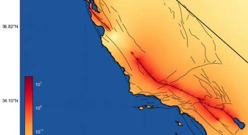
QuakeSim, developed at NASA's Jet Propulsion Laboratory (JPL) in Pasadena, Calif., is a comprehensive, state-of-the-art software tool for simulating and understanding earthquake fault processes and improving earthquake forecasting. Initiated in 2002, QuakeSim uses NASA remote sensing and other earthquake-related data to simulate and model the behavior of faults in 3-D both individually and as part of complex, interacting systems. This provides long-term histories of fault behavior that can be used for statistical evaluation. Quakesim also is used to identify regions of increased earthquake probabilities called hotspots.
Studies have shown QuakeSim to be the most accurate tool of its kind for intermediate earthquake forecasting and detecting the subtle, transient deformation in Earth's crust that precedes and follows earthquakes. Its varied applications include scientific studies, developing earthquake hazard maps that can be used for targeted retrofitting of earthquake-vulnerable structures, providing input for damage and loss estimates after earthquakes, guiding disaster response efforts, and studying fluid changes in reservoirs, among others.
More information: For more information about NASA's Inventions and Contributions Board, visit: icb.nasa.gov
Provided by NASA


