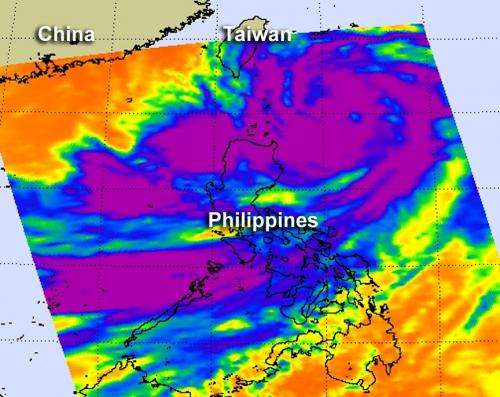
NASA's Aqua satellite passed over Typhoon Saola on July 30 at 0517 UTC (1:17 a.m. EDT) and the AIRS instrument captured an infrared image of the storm. It showed that strong, high, cold cloud tops of thunderstorms (purple) extended from the center of circulation some 300 miles from Taiwan southwest over the Philippines. Credit: Credit: NASA JPL, Ed Olsen
Typhoon Saola looks like a monster tropical cyclone in infrared imagery from NASA's Aqua satellite today, July 30. Although Saola's center is over 300 nautical miles (368 miles/592 km) south-southeast of Taiwan, it stretches over the north and central Philippines and has triggered a number of warnings throughout the country.
The Moderate Resolution Imaging Spectroradiometer (MODIS) instrument on NASA's Terra satellite captured an image of Typhoon Saola approaching Taiwan on July 30 at 0215 UTC (July 29 at 10:15 p.m. EDT). The image showed a ragged eye in the storm's center and the huge extent of the storm's clouds, stretching southwest over the Philippines. For a high resolution, unlabeled MODIS image, visit this link.
NASA's Aqua satellite passed over Typhoon Saola a couple of hours after the Terra satellite. On July 30 at 0517 UTC (1:17 a.m. EDT) and the Atmospheric Infrared Sounder (AIRS) instrument onboard the Aqua satellite captured an infrared image of the storm. It showed that strong, high, cold cloud tops of thunderstorms extended from the center of circulation some 300 miles from Taiwan southwest over the Philippines. The eye of the storm appeared much clearer on the AIRS infrared imagery than on the visible MODIS imagery.
On July 30, the following warnings were posted in the Philippines: Public storm warning signal #1 is in effect for the following provinces of Luzon: Apayao, Isabela, and Kalinga. Public storm warning signal #2 is in effect for the Luzon province of Cagayan and the Babuyan and Calayan groups of islands. Public storm warning signal #3 is in effect for the Batanes group of islands.
Forecasters at the Joint Typhoon Warning Center expect Saola to continue on a northwesterly track taking the center just north of Taipei, Taiwan on Wednesday, August 2. That means strong winds, heavy rainfall, and very rough coastal conditions for Taiwan.
On July 30 at 1500 UTC (11 a.m. EDT) Saola had maximum sustained winds near 65 knots (75 mph/120.4 kmh). It was centered 320 nautical miles (368 miles/592.6 km) south-southeast of Taipei, Taiwan near 20.6 North and 124.6 East. Saola is moving slowly to the northwest at 5 knots (5.7 mph/9.2 kmh), meaning more rainfall for the Philippines and more potential for flooding.
The Joint Typhoon Warning Center expects Saola to continue intensifying over the next couple of days and will make landfall in mainland China sometime on Thursday, August 3.
Provided by NASA's Goddard Space Flight Center


