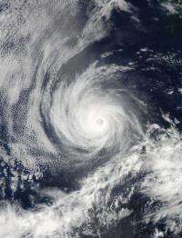
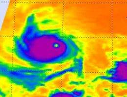
NASA's Aqua satellite providing two views of Hurricane Emilia

NASA's Aqua satellite has several instruments onboard that are providing forecasters with different views of Hurricane Emilia in the Eastern Pacific Ocean. The infrared view hinted that Emilia would strengthen and it regained Category 3 Hurricane status today.
On Wednesday, July 11, 2012 at 2120 UTC (5:20 p.m. EDT/2:20 p.m. PDT), the Moderate Resolution Imaging Spectroradiometer (MODIS) instrument captured a visible image of Hurricane Emilia that showed an eye with some high clouds overhead. The next day, Thursday, July 12, the Atmospheric Infrared Sounder (AIRS) instrument on Aqua captured an infrared image of Hurricane Emilia at 0929 UTC / 5:29 a.m. EDT. The infrared data showed strong thunderstorms and cold cloud tops surrounding the eye of the hurricane. Some of the cloud top temperatures were almost as cold as 210 kelvin (-81.6 Fahrenheit/-63.1 Celsius), indicating powerful thunderstorms approaching the top of the troposphere.

Those observations of powerful thunderstorms around Emilia's eye happened before Emilia again strengthened and were an indication that the storm would intensify. By 11 a.m. EDT on July 12, Emilia's maximum sustained winds had increased again to near 115 mph (185 kmh) and Emilia regained category three hurricane status on the Saffir-Simpson hurricane wind scale. The center of Hurricane Emilia was located near latitude 15.1 north and longitude 121.4 west. That's about 925 miles (1485 km) southwest of the southern tip of Baja California. Emilia is moving toward the west near 12 mph (19 kmh) and this general motion is expected to continue for the next two days. Because Emilia is headed toward cooler waters, she is again expected to weaken over the next several days.
Provided by NASA's Goddard Space Flight Center


