July 23, 2012 weblog
Earth scientists use fractal analysis to uncover ancient Egyptian pyramid practice site

(Phys.org) -- A team of Earth scientists from Germany has turned to fractal pattern recognition analysis to study a part of the ground that makes up a river delta, and has found evidence of pyramid building practice by the father of the man believed to be responsible for building the Great Pyramid of Giza. The team describe their technique and results in their paper published in the journal Quaternary International.
Fractals are natural or artificially created geometric patterns that form designs that appear to repeat themselves when magnified, over and over again. In nature, deltas created where rivers meet the ocean quite often display fractal properties, and because of this, the research team used fractal analysis to determine the extent of the Dahshur royal necropolis near Cairo, a site believed to have been used by King Sneferu to develop pyramid building skills. Sneferu’s son, Khufu, is believed to be responsible for building the Great Pyramid of Giza, one of the great man-made wonders of the world.
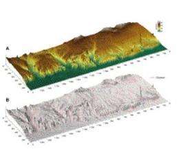
Since the time of Sneferu, some 4500 years ago, nature has worked to wash away virtually all evidence of human endeavors, and in fact, surveying the region with the naked eye reveals very little evidence of the ancient Egyptians activities. It was for this reason that the team turned to fractals. Their reasoning was that man made changes to the landscape would differ from natural fractal patterns as seen from far above, and that those changes would take significantly longer to wash away. And that’s exactly what the team found. After taking pictures of the site from an airplane and then running them through digital fractal analysis, they found distinct differences between land that developed naturally and land that was disturbed by the ancient civilization still learning how to build the monuments that have become their legacy.
The team was surprised to learn of the large area size involved - six square kilometers that differ so markedly from the surrounding terrain after digital alterations, that the early plain is clearly visible. So clear were the images produced, the researchers were able to discern some geographical properties of the land, which they identified as broad terraces that they surmise were used to increase the impressiveness of the pyramids themselves.
Because the effort proved largely successful, it’s likely other teams will employ it as well on other land areas, possibly uncovering other features that have until now, remained hidden in plain sight.
More information: Fractals in topography: Application to geoarchaeological studies in the surroundings of the necropolis of Dahshur, Egypt, Quaternary International, Volume 266, 17 July 2012, Pages 34–46. dx.doi.org/10.1016/j.quaint.2012.02.045
Abstract
The necropolis of Dahshur in northern Egypt witnessed human–environment interaction on a millennial scale but to an unknown extent. The present study aims to decipher ephemeral channel networks, which are common landscape features in the surroundings of the necropolis, from landforms that were subject to human influence. The analysis was carried out on the basis of surface geometry as derived from a digital elevation model (DEM). The hypothesis is tested that the natural fractal patterns of channel networks lead to fractal surface topography, when fluvial processes are the main factors for relief evolution. Therefore, the estimated fractal dimension of channel networks is correlated with the fractal dimension of surface topography to determine the mutual functional relationship. A high degree of functional relationship within some areas of the DEM shows that channel networks are self-similar branching trees that imprint their geometry on to surface topography in a scale range of ∼15 to ∼190 m. A low correlation of fractal patterns of channel network and surface topography in the vicinity of the pyramid district of the necropolis is interpreted as channel beds modified or induced by human impact, either due to the usage of the channel beds as transport ways for building material leading to an acceleration of processes like soil erosion or due to direct activities like mining or landscape architecture.
via Newscientist
© 2012 Phys.org


