NASA's TRMM views forming tropical cyclone

System 94E and System 95E are low pressure areas located off the western coast of Mexico that are being watched by forecasters and by satellites. Each of them has the potential for development into a tropical cyclone, although System 95E has a greater chance. That low was recently spotted by NASA's TRMM satellite, which provided rainfall and cloud height data to forecasters.
The National Hurricane Center (NHC) has warned that another tropical cyclone is probably forming from System 94E, located south of Guatemala and El Salvador. The TRMM satellite flew over on June 13, 2012 at 1032 UTC (6:32 a.m. EDT).
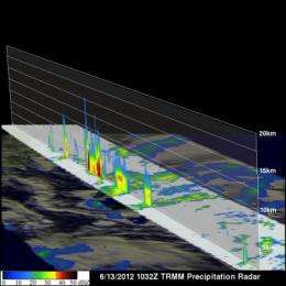
TRMM's Microwave Imager (TMI) and Precipitation Radar (PR) data were overlaid on an enhanced infrared image from TRMM's Visible and InfraRed Scanner (VIRS) instrument to create an image of rainfall rates occurring in the low pressure area. This analysis, created at NASA's Goddard Space Flight Center in Greenbelt, Md. showed heavy rainfall was occurring in a line of intense convective storms within the potential tropical cyclone. TRMM PR found that some of these storms were returning high reflectivity values of over 51.675 dBz providing more proof of intense rainfall in that area.
TRMM PR data was also used to create a 3-D vertical image of the storm, showing a slice though the center of the highest storm towers. This cross-section shows that convective towers within this area were reaching heights of over 15km (~9.3 miles). The energy released by heavy rainfall within these towers can hasten the birth of a tropical cyclone.
At 8 a.m. EDT (5 a.m. PDT) on June 13, 2012 the National Hurricane Center noted that System 94E was about 375 miles south of the border of Guatemala and El Salvador. Satellite imagery shows that it has become more organized. System 94E continues to track to the west-northwest at 10 mph and has a 60 percent chance of becoming a tropical depression in the next two days. Meanwhile, System 95E, located west of System 94E and several hundred miles south of Acapulco, Mexico has become less organized in the last day, and has a 20 percent chance of development over the next couple of days.
Provided by NASA's Goddard Space Flight Center


