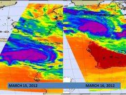
When NASA's Aqua satellite passed over northern Australia on March 15 at 1741 UTC and March 16 at 0553 UTC it captured infrared images of Tropical Cyclone Lau. The later image appeared to show that Lau was becoming more organized and more compact, signs that the storm was strengthening. Over that time period the storm had grown from a tropical storm to a cyclone. Aqua captured an infrared image of the storm's cloud top temperatures using the Atmospheric Infrared Sounder instrument. AIRS data showed that the coldest (purple) cloud top temperatures (colder than -63F/-52.7C). Credit: Credit: NASA/JPL, Ed Olsen
Northern Australia's Pilbara coast is under warnings, alerts and watches as powerful Cyclone Lua nears for a landfall. NASA's Aqua satellite has been providing infrared, visible and microwave data on Lua that have shown forecasters the storm is strengthening on its approach to land.
Two of the most recent infrared images of Cyclone Lua were captured from the Atmospheric Infrared Sounder (AIRS) instrument onboard NASA's Aqua satellite. The AIRS instrument captured infrared images of Cyclone Lua on March 15 at 1741 UTC and March 16 at 0553 UTC. The later image appeared to show that Lau was becoming more organized and more compact, signs that the storm was strengthening. Bands of thunderstorms are also wrapping into the low-level center, another sign of strengthening. Over that time period the storm had grown from a tropical storm to a cyclone. Aqua captured an infrared image of the storm's cloud top temperatures using the Atmospheric Infrared Sounder (AIRS) instrument. AIRS data showed that the coldest (purple) cloud top temperatures (colder than -63F/-52.7C).
The list of warnings, watches and alerts are numerous. A Cyclone Warning is current for coastal areas from Cape Leveque to Dampier, including Port Hedland, Karratha, Dampier and Broome, as well as inland parts of the eastern Pilbara and far western Kimberley. A Cyclone Watch is current for the central and eastern inland Pilbara including Telfer, Newman and Paraburdoo, the western inland Kimberley, the eastern Gascoyne including Meekatharra, and the far western Interior.
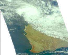
When NASA's Aqua satellite passed over Tropical Cyclone Lau on March 16 at 0553 UTC it captured this visible image of the storm approaching the Pilbara coast. Credit: NASA/JPL, Ed Olsen
Yellow and Blue Alerts are also in effect. A Yellow Alert is in effect for residents between Broome and Whim Creek including Bidyadanga, Port Hedland, South Hedland, Warralong, Yande Yarra, Marble Bar and adjacent pastoral and mining leases. A Blue Alert is in effect for residents in coastal communities between Whim Creek and Dampier including Karratha, Dampier, Roebourne, Wickham and Point Samson as well as inland communities including Nullagine, Newman and Jigalong and surrounding pastoral and mining leases.
ABC Online Melboure reports that flights have been canceled and roads have been closed. Officials have also closed Karijini National Park because of flash flooding risk.
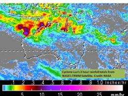
NASA's TRMM satellite can add up rainfall totals from space, and from 0900 to 1200 UTC (5am-8am EST), Cyclone Lua was dropping about 1 inch every 3 hours in the purple areas in this image from today, March 16, 2012. Credit: NASA TRMM
On March 16, 2012 at 0900 UTC (5 a.m. EST), Tropical cyclone Lua's maximum sustained winds were near 75 knots (86 mph/139 kph). Cyclone-force winds extended out 30 nautical miles (34.5 miles/55.5 km) from the center, while tropical storm-force winds extended out to 160 nautical miles (184 miles/296.3 km) from the center.
Lua was located near 16.5 South and 116.6 East, about 260 miles north-northwest of Port Hedland, Australia. Lua was moving to the east-southeast at 10 knots (11.5 mph/18.5 kph).
Lua is forecast to strengthen to 90 knots (103.6 mph/166.7 kph) before making landfall around midday (local time) on March 17 just north of Port Hedland. By March 19, Lua is expected to dissipate in central or southern Western Australia. The Australian Bureau of Meteorology is issuing updates every three hours. To see the updates, visit: http://www.bom.gov.au/cyclone/.
Provided by NASA's Goddard Space Flight Center


