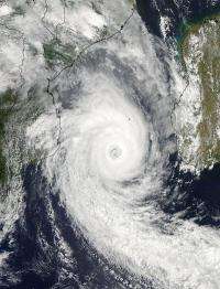
NASA's Aqua satellite passed over Tropical Cyclone Funso on January 26 at 1110 UTC (6:10 a.m. EST). The Moderate Resolution Imaging Spectroradiometer, better known as the MODIS instrument captured a true color image of the storm that showed a 25 nautical-mile-wide eye, and clouds swirling down into it. The outer extent of Funso's clouds skirted Madagascar to the east, and Mozambique to the west. Credit: Credit: NASA Goddard MODIS Rapid Response Team
Powerful Cyclone Funso is now beginning to exit the Mozambique Channel, and NASA's Aqua satellite captured a stunning image of the storm that shows the depth and extent of it.
NASA's Aqua satellite passed over Tropical Cyclone Funso on January 26 at 1110 UTC (6:10 a.m. EST). The Moderate Resolution Imaging Spectroradiometer, better known as the MODIS instrument captured a true color image of the storm that showed a 25 nautical-mile-wide (29 miles/~46 km) eye, and clouds swirling down into it. The outer extent of Funso's clouds skirted Madagascar to the east, and Mozambique to the west.
At 0900 UTC (4 a.m. EST) on January 26, Funso's maximum sustained winds were down to 100 knots (115 mph/185 kph). It was located about 277 nautical miles (319 miles/513 km) east-northeast of Maputo, Mozambique. Its center was pinpointed near 24.0 South latitude and 39.2 East longitude. It was moving to the south-southeast near 4 knots (4.6 mph/7.4 kph). The storm is over 400 nautical miles (460 miles/~741 km) in diameter, which is the extent of tropical-storm-force winds.
Funso is expected to maintain cyclone strength over the next couple of days as it moves out of the Mozambique Channel and into the open waters of the Southern Indian Ocean, where it will begin to weaken.
Provided by NASA's Goddard Space Flight Center


