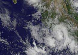
This GOES-11 image from Aug. 31 at 12:15 p.m. EDT, shows Tropical Depression 8E as a rounded swirl of clouds hugging Mexico's southwestern coastline. Credit: NASA/NOAA GOES Project
The Mexican government has issued a tropical storm watch for the coast of southwestern Mexico from Zihuatanejo to Punta San Telmo as Tropical Storm 8E formed this morning. The GOES-11 satellite captured an image of its rounded clouds hugging this coast this morning, and NASA's TRMM satellite noticed some heavy rainfall in the system yesterday.
Forecasters noticed the depression develop more rounded characteristics on imagery from NOAA's GOES-11 satellite today. The image was created by the NASA GOES Project at NASA's Goddard Space Flight Center, Greenbelt, Md.
On Aug. 30, NASA's Tropical Rainfall Measuring Mission (TRMM) satellite noticed some isolated areas of heavy rainfall within the low pressure area before it organized. Some areas had rainfall rates of 2 inches (50 mm) per hour.
Today, August 31 at 11 a.m. EDT, Tropical Depression 8E had maximum sustained winds near 35 mph. It was located just 75 miles (120 km) west-northwest of Zihuatanejo, Mexico, near 18.0 North and 102.7 West. It was moving northwest near 7 mph (11 kmh) and is expected to crawl in that direction over the next couple of days, making rainfall a problem for coastal areas.
Tropical Depression 8E is forecast to hug the western Mexico coastline over the next couple of days, and not strengthen because of its proximity to land. It will, however bring heavy rainfall to coastal sections of the Mexican states of Guerrero, Michoacan and Colima. The National Hurricane Center expects 4 to 6 inches with isolated maximum amounts of 12 inches.
The depression is expected to be short-lived because of its interaction with land, and the National Hurricane Center forecasts it to become a remnant low by late Thursday.
Provided by NASA's Goddard Space Flight Center


