April 29, 2011 report
GPS data reveals more on mega-thrust earthquakes

(PhysOrg.com) -- New GPS data of the 2010 earthquake that devastated parts of Chile and killed over 500 people is revealing new clues about large earthquakes such as the quake in Chile and the magnitude 9.0 earthquake that struck near the east coast of Japan on 11 March this year.
The largest earthquakes, called mega-thrust earthquakes, occur when a tectonic plate is forced under another in a process known as subduction. Little is understood of the physics of these >8.5 magnitude earthquakes because they have been so rare in recorded history, but global positioning system (GPS) stations are now able to measure exactly what happens to the earth’s surface during earthquakes and is helping physicists understand the process better.
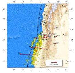
An international research team led by geophysicist Christophe Vigny of the Centre National de la Recherce Scientifique in Paris, France has been analyzing GPS data of the magnitude 8.8 Chile earthquake. Data from over 20 GPS stations was available for the area of the rupture, and the information was in unprecedented detail, allowing the researchers to measure changes on the surface of as little as only a couple of millimeters. The precise information has allowed the researchers to more accurately model what was happening in the mega-thrust quake.
In the Chile earthquake zone the oceanic Nazca Plate is subducting under the continental South American Plate. The GPS data revealed the location of the epicenter, the point on the surface directly above the rupture, was about 40 kilometers southwest of the original estimates. The rupture spread 500 km across the subduction zone at a rate of over three kilometers per second, with the two sides of the fault slipping up to 15 meters past each other.
Dr Vigny said, in a paper published in the journal Science, that knowing the precise length of the rupture allows the researchers to assess the stresses remaining on the sections of the fault that did not rupture. In Chile, the subduction zone is around 4,000 km long, which means 3,500 km did not rupture.
There is also a network of hundreds of GPS stations in Japan, and the data gathered by these stations will also add to our understanding of mega-thrust earthquakes. Dr Vigny said the Chile data and preliminary data from Japan suggest the mega-thrust earthquakes occur in regions where the faults are “highly locked” with the two tectonic plates locked together and not moving because of friction, which means an enormous amount of energy is able to build up and is only released when the fault ruptures.
Dr Vigny said if other regions are not completely locked, the indications are that mega-thrust earthquakes are unlikely to occur there, but he cautioned that we have good GPS data for so few earthquakes that it is not possible to know for certain. Regions where tectonic plates are currently locked and could cause mega-thrust earthquakes in the future include a region in northern Chile and the Nankai Trough to the south of Japan.
Most of the large earthquakes have occurred in the so-called “Ring of Fire”, with the largest since recordings began occurring in Valdivia, Chile, in 1960. The 1960 earthquake was magnitude 9.5 and left an estimated 1,655 dead and over two million people homeless. The death toll of the Japanese earthquake and tsunami in March this year could exceed 10,000 dead.
More information: The 2010 Mw 8.8 Maule Mega-Thrust Earthquake of Central Chile, Monitored by GPS, Science, DOI:10.1126/science.1204132
ABSTRACT
Large earthquakes produce crustal deformation that can be quantified by geodetic measurements, allowing for the determination of the slip distribution on the fault. We use data from Global Positioning System networks in Central Chile to infer the static deformation and the kinematics of the 2010 Mw 8.8 Maule mega-thrust earthquake. From elastic modeling, we find a total rupture length of ~500 km where slip (up to 15 m) concentrated on two main asperities situated on both sides of the epicenter. We find that rupture reached shallow depths, probably extending up to the trench. Resolvable afterslip occurred in regions of low coseismic slip. The low-frequency hypocenter is relocated 40 km southwest of initial estimates. Rupture propagated bilaterally at ~3.1 km/s, with possible but not fully resolved velocity variations.
© 2010 PhysOrg.com


