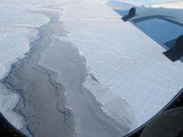
Arctic sea ice flights near completion

(PhysOrg.com) -- Operation IceBridge, NASA's airborne mission to monitor polar ice, is amid its fourth week of flights for the Arctic 2011 campaign. Researchers and crew successfully completed flights from Thule, Greenland, to monitor sea ice and have now moved to Kangerlussuaq, Greenland to focus on flights monitoring the ice sheet.
Flying a distance of about 19,000 miles [30,000 kilometers] over the Arctic Ocean, scientists onboard the P-3 collected data during eight sea ice flights based from Thule Air Base. One additional sea ice flight remains to be flown from Kangerlussuaq.
Why Fly Sea Ice?
Sea ice flights, flown this year from March 16-28, take priority early in the mission’s Arctic campaigns. That's because sea ice typically reaches its annual maximum extent in March, and scientists want to collect data before the ice begins to melt and retreat during northern hemisphere's summer. This year, sea ice reached its maximum extent on March 7, reaching 5.7 million square miles and tying for the lowest extent since the start of satellite measurements in 1979.
The thickness of Arctic sea ice cover is also declining, on average, throughout the satellite record, according to scientists including Joey Comiso of NASA's Goddard Space Flight Center in Greenbelt, Md. Now, after the Ice, Cloud, and land Elevation Satellite (ICESat) stopped collecting data in 2009, IceBridge continues to collect the data scientists need to observe sea ice thickness.
The mission's airborne instrument suite collects lidar and radar data making it possible to monitor both the sea ice freeboard and the snow layer on top of the sea ice. Both measurements are important for quantifying the sea ice thickness and predicting the heat exchange between the Arctic Ocean and the atmosphere.
Flight Highlights
On March 22, IceBridge teams flew to Fairbainks, Alaska. Despite hazy weather conditions, instruments collected data over varying sea ice types across the entire Arctic basin.
Then, on March 23, the P-3 flew one of the campaign's most challenging flights -- an overpass of the U.S. Navy's ICEX camp, an assemblage of tents and shacks drifting on an ice floe north of Fairbanks. On the ground with ICEX was a team of researchers from the Army’s Cold Regions Research & Engineering Laboratory and the Naval Research Laboratory, who established a line that would be surveyed from on, below and above the ice. Comparing measurements from each vantage point helps scientists improve the accuracy of sea ice thickness measurements.
Sea ice camps are moving targets, drifting along with the wind and ocean currents. The erratic movement makes for a challenging overflight.
"The sea ice moves unpredictably, crazy, like a drunken sailor," said John Sonntag of URS Corporation, and the IceBridge instrument team lead.
Just before the mission, the camp was floating north at about 66 feet per hour, but by the time the aircraft was nearby it had suddenly veered east at about 660 feet per hour. The flyover required precise coordination with ground teams before and during the flight.
The P-3 returned to Thule on March 25 to complete three more science flights before transiting to Kangerlussuaq, the base of operations for the next few weeks.
Land Ho!
The single remaining sea ice flight planned to fly from Kangerlussuaq will overfly a CRYOVEX site. The sites are designed to calibrate the European Space Agency's ice-observing satellite, CryoSat-2. Overflying the site will help scientist link the ICESat, IceBridge and Cryosat-2 datasets.
Meanwhile, IceBridge scientists are working to complete a series of land ice flights. To date, IceBridge has completed four land ice flights over west Greenland. Weather has been favorable in that area, which is typical. Upcoming land ice missions to southeast Greenland will rely on a bit more luck, as low pressure from the Icelandic low commonly produces clouds in the region.
Provided by JPL/NASA


