Vision of the disastrous tsunami rolling onto Japan after last week's massive 9.0-magnitude earthquake will provide valuable data to scientists for years to come, Australian experts said Wednesday.
Vision of the disastrous tsunami rolling onto Japan after last week's massive 9.0-magnitude earthquake will provide valuable data to scientists for years to come, Australian experts said Wednesday.
Compelling images of the monster wave crashing onto low-lying farmland in Japan's northeast, sweeping all in its path into a surging waterway, was played live by television stations as helicopter-borne crews recorded the event.
"I think the impact of the waves going across and spreading well inland on relatively flat terrain was something that we've never seen before," Australian tsunami expert Ray Canterford told AFP, adding it was a tragedy for Japan.
"This is quite a unique event."
Canterford said while scientists had made progress on predicting tsunamis since the devastating 2004 Indian Ocean disaster in which some 220,000 people died, there was still work to be done.
"There has been progress but it's very unfortunate for the Japanese, who are probably one of the most tsunami-ready countries in the world, to be impacted like this -- it's just so tragic," he said.
Bureau of Meteorology scientist Diana Greenslade said the footage from Japan, which showed houses and buildings being swept up in the torrent of water racing inland, would be of deep interest to scientists studying tsunamis.
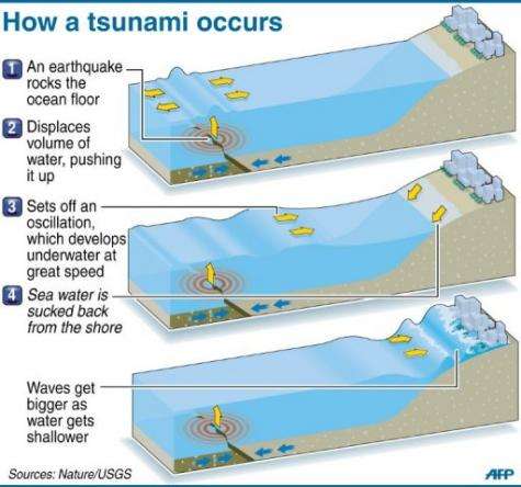
Graphic explaining how a tsunami forms after an earthquake. A massive earthquake that hit Japan Friday generated a 10-metre tsunami.
"In the future it will be useful," said Greenslade, principal research scientist at the bureau, adding that scientists would be keen to use the footage to help verify their tsunami modelling systems.
Scientists typically have relied on measuring tsunami waves using tide gauges and then going into tsunami-hit zones after the waves have passed to measure how far the water penetrated inland.
"But what we can get from the vision is a whole bunch of other things as well," she said, including the flow's speed and depth, the extent of the inundation, and how debris churning in the water affects the speed of the flow.
"The amount of video from this one, especially the one from the helicopter where you can actually see the wave front inundating onto the land is just exactly what we need to be able to verify our models," Greenslade said.
She said it would be especially valuable in working out the speed and strength of tsunami currents -- which are currently very difficult to assess.
Canterford, head of weather and ocean services at the Bureau of Meteorology, said that huge improvements in tsunami modelling had been made since the 2004 disaster, which hit countries from Indonesia to Kenya.
At the time, it was not possible to predict straight after the earthquake whether a tsunami would hit Australia.
On this occasion, he said, "for Australia in particular we were aware almost immediately, because of our modelling and because of our instrumentation, that it wouldn't impact on our coastline.
"That's no good for Japan or other countries but four or five years ago we would have to have evacuated coastal communities as well because we wouldn't have known where it was."
(c) 2011 AFP


