New model changes view of climate change
(PhysOrg.com) -- Using new, high-resolution global ocean circulation models, University of Massachusetts Amherst geoscientist Alan Condron, with Peter Winsor at the University of Alaska, report this week that massive glacial meltwaters assumed to have flooded the entire North Atlantic 8,200 years ago, drastically cooling Europe, instead flowed thousands of miles further south. "These results dramatically affect our understanding of what causes climate change," Condron says.
The events unfolded when the Laurentide ice sheet, which covered much of Hudson Bay in Arctic Canada, gradually melted during a warm period about 8,200 years ago. The resulting glacial Lake Agassiz catastrophically broke through a kilometers-long ice dam at the bottom of the bay, suddenly dumping thousands of cubic kilometers of fresh water into the Atlantic Ocean.
Because this roughly coincided with the largest abrupt climate change recorded in the last 10,000 years, classic geoscience theory had assumed that the flood covered the surface of the Labrador and Greenland Seas and subpolar gyre with lighter, warmer and less salty water to trigger the cooling. Scientists have assumed this slowed the Gulf Stream and ocean convection by disrupting the Thermohaline circulation, that is, the large-scale temperature- and salt-driven ocean current responsible for our current warm, stable climate.
However, Condron and Winsor’s new model, which is 10 to 20 times more powerful than previously attainable, suggests the freshwater flood of 8,200 years ago and others like it actually skirted past the subpolar gyre, instead traveling south by joining narrow, coast-hugging currents where water moves much faster than in the open ocean.
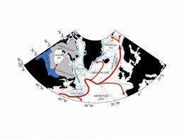
They summarize, "Using a high resolution, global, ocean-ice circulation model, we present an alternative view that freshwater discharged from glacial Lake Agassiz would have remained on the continental shelf as a narrow, buoyant, coastal current and would have been transported south into the subtropical North Atlantic."
If they’re correct and fresh water from glacial Lake Agassiz did end up in the Gulf Stream much farther south, between 20 and 40 degrees of latitude in the subtropical gyre, it’s revolutionary. "Basically, our model says that this flood ended up 3,000 miles further south than we all thought. It’s observed at the same time as the climate change and cooling in Europe, but the picture is far more complicated and different than we’d assumed. We all thought it went much further north."
The new model runs on one of the world’s top supercomputers at the National Energy Research Science Computing Center in Berkeley, Calif. "With this higher resolution modeling, our ability to capture near-shore boundary currents dramatically changes our idea of where the fresh water may be going. Lower-resolution models very much miss the complexity and detail that are now available in our high-res model," the authors say. Their findings appear in the current issue of Geophysical Research Letters.
Condron says the revised view is a result of much higher computational power available with faster computers. Older models weren’t powerful enough to catch these subtleties because they contained too few data points to capture smaller-scale, faster-moving coastal currents. "We’ve shown that the conceptual idea in which flood waters once covered the subpolar gyre derives from the inability of lower resolution numerical models to accurately resolve narrow coastal flows, and is likely incorrect," he adds.
The new model is strengthened, Condron says, by present-day evidence that this coastally confined freshwater pathway is the same route taken by water flowing out of Hudson Bay now. Further, paleooceanographic evidence from the coastal shelf ocean supports this new view. "When we look offshore in the open ocean there really is very little evidence for this flood event, but there are clear sedimentary deposits from a large flood along the shelf."
"Our results are particularly relevant for how we model the melting of the Greenland and Antarctic ice sheets now and in the future. "It’s apparent from our results that climate scientists are artificially introducing fresh water into their models much too far north, into parts of the ocean that it never would have reached. This has strong implications for predicting and understanding the stability of our future climate," says Condron. "We’re in a similar interglacial period now, in the Holocene. The assumption is that the ocean looked and acted then much the same as it does today. So the coastal currents are assumed to be the same."
Their next step will be to understand the impact caused by this freshwater flooding into the subtropical, rather than the subpolar ocean to see if it may be related to cooling and climate disruption.
Provided by University of Massachusetts Amherst


