NASA Aqua Satellite sees powerful Cyclone Yasi make landfall in Queensland, Australia

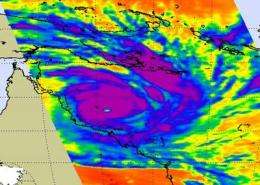
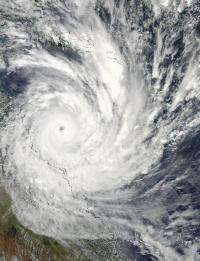
NASA's Aqua satellite captured visible and infrared imagery of powerful Cyclone Yasi as it was making landfall in Queensland. The center of the monster cyclone Yasi made landfall on Australia's northeastern coast early Thursday (Australia local time) bringing heavy rainfall, severe winds and storm surge.
On Feb. 2 at 03:35 UTC/1:35 p.m. Australia local time, the Moderate Resolution Imaging Spectroradiometer (MODIS) instrument on NASA's Aqua satellite captured a visible image of Cyclone Yasi before it made landfall in Queensland, Australia. The eye of the cyclone was very clear and indicative of the power of this tropical cyclone. Damaged buildings, downed trees and power outages have been reported.
A Cyclone Warning is still in effect today for coastal and island communities from Cooktown to Proserpine, and west inland to the Northern Territory border. The Cyclone Warning was cancelled between Cape Flattery and Cooktown. The Australian Bureau of meteorology warned that flooding rains between Cairns and Proserpine will gradually move inland as Yasi tracks to the west. Flood Warnings are in effect for several rivers between Cairns and MacKay
At 03:29 UTC/1:29 p.m. Australia local time on February 2 (10:29 p.m. EST, Feb. 1), the Atmospheric Infrared Sounder (AIRS) instrument captured an infrared image of Cyclone Yasi as its center was just southeast of Willis Island. The infrared image showed powerful thunderstorms with strong convection and heavy rainfall surrounding a large area around a very clear eye. The temperatures in the cloud tops were as cold as or colder than -63 Fahrenheit (-52 Celsius).

Tropical Cyclone Yasi was making landfall as a powerful Category Four cyclone with maximum sustained winds near 135 knots (155 mph/ 250 kmh) on Feb. 2, at 1500 UTC (10 a.m. EST/ 1 a.m. Australia local time on Feb. 3). It was located about 245 miles east of Cairns near 17.5 South and 146.8 East and moving west-southwest near 13 knots (15 mph/ 24 kmh). Maximum waveheights associated with Yasi were 42 feet (~13 meters) in the Coral Sea.
The automated Bureau of Meteorology (BoM) weather station on Willis Island provided amazing data this morning as Cyclone Yasi swept past. Willis Island is located east of Queensland, Australia. Rainfall exceeded 60 mm (2.36 inches) in one hour and pressure had fallen to near 938 millibars. Windspeed peaked at 75 knots (86 mph/138 kmh) before the equipment stopped working.
As Yasi made landfall and swept inland, Cairns, located to the north of Townsville, recorded a low reading of atmospheric pressure near 983 millibars. Rainfall was 16 mm (0.6 inch) in one hour, and maximum sustained winds were recorded as high as 34 knots (39 mph/63 kmh).
At 3 a.m. local time, the center of Severe Tropical Cyclone Yasi had moved inland and was located near 18.1 South and 145.4 East. It was moving west-southwest near 33 kmh (20 mph) and had a minimum central pressure of 941 millibars. The storm is forecast to weaken and dissipate within 48 hours.
Provided by NASA's Goddard Space Flight Center


