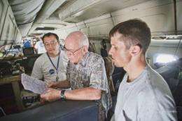
GRIP mission scientist Ed Zipser (center), of the University of Utah, reviews flight plans during one of the DC-8's final flights with Matt He (left), NASA's Marshall Space Flight Center) and Utah student Jon Zawislak. Credit: Sean Smith/LaRC
NASA wrapped up one of its largest hurricane research efforts ever last week after nearly two months of flights that broke new ground in the study of tropical cyclones and delivered data that scientists will now be able to analyze for years to come.
While the 2010 hurricane season has been a rather quiet one for coastal dwellers, the churning meteorology of the Atlantic Ocean and Caribbean Sea seemed to cooperate well with the science goals of Genesis and Rapid Intensification Processes (GRIP) experiment. Those goals were designed to answer some of the most fundamental yet still unanswered questions of hurricane science: What ultimately causes hurricanes to form? Why do some tropical depressions become strong hurricanes, while others dissipate? What causes the rapid strengthening often seen in hurricanes?
Mission scientists wanted to capture data on hurricanes as they formed and intensified. Ideally, the NASA planes – the DC-8, WB-57 and Global Hawk – would also fly over systems that were weakening, or that were expected to form into hurricanes yet did not. When the flights had ended, all those goals had been met.
"It was successful beyond my reasonable expectations. It requires cooperation with the weather, and good luck with the aircraft," said mission scientist Ed Zipser, of the University of Utah. "It's not so much a logistical challenge as it is a toss of the dice by Mother Nature during our time available. But it takes a good airplane, a skillful crew and good luck with the equipment."
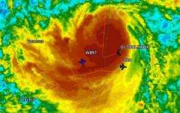
Hurricane Karl gave the GRIP team one of the best opportunities to study a tropical storm. On Sept. 16, all three NASA aircraft flew above Karl simultaneously as it approached the coast of Mexico, captured in this screen grab from GRIP's Real-Time Mission Monitor. Credit: NASA
Flying to Hurricanes
Hurricanes Earl and Karl each became important objects of observation for scientists during GRIP. The DC-8 flew to Earl four times, criss-crossing the storm as it intensified to a category 4 hurricane and then weakened. On the final Earl flight, as the storm was breaking down and losing strength, the Global Hawk made its debut hurricane flight and passed over Earl's eye in concert with the DC-8, providing valuable comparison measurements for the instruments on-board both aircraft. The WB-57 also flew Earl as well as Karl.
At the outset, scientists hoped that several aspects of GRIP would help gather important data as well as complete a couple of technical accomplishments. First, collaboration with the Air Force, NOAA and the National Science Foundation would allow scientists to observe a single storm system with as many as six aircraft. Second, GRIP featured the debut of NASA's Global Hawk drone in a hurricane research capacity. The unmanned plane's 24-hour flight range gave scientists the ability to directly observe a hurricane as it changed over time and distance in a way that conventional planes and satellites have not done before.
Both of these aspects of GRIP were used to great effect during the two major hurricanes observed during the campaign, Earl and Karl. "We're all very pleased we were able to get the Global Hawk over a hurricane," said mission scientist Gerry Heymsfield, of NASA's Goddard Space Flight Center, Greenbelt, Md. "There was a question about that. That's a major accomplishment both on the science side and the capability side. It really paves the way for future research."
As the campaign went on, Global Hawk pilots, based remotely at Dryden Flight Research Center, near Palmdale, Calif., grew more comfortable with the drone's capability at 60,000 feet and over a hurricane. On Sept. 16 and 17, the Global Hawk made a 25-hour flight that included 20 passes over the eye of Karl as it was emerging into a hurricane – precisely the type of formation and storm development that scientists hoped to capture during GRIP.
"None of our other planes can do that," said GRIP project manager Marilyn Vasques, of Ames Research Center, Moffett Field, Cal. "They've been learning the capabilities of this aircraft at every flight. We challenged it more and more, and the aircraft and Dryden have performed really well."
On that same flight, the collaboration with the other agencies reached full steam, as six aircraft flew over Karl. The DC-8 was even able to follow the storm after it made landfall in Mexico and began to deteriorate. It is unusual to get the clearances to fly over a hurricane once it has reached land, making the scientific payoff all the more valuable. "We were able to capture some rare detail once it made landfall," Zipser said.
What's in the data?
For all the logistics involved in coordinating flights and using a drone designed for military purposes in a scientific campaign, the chief purpose of the experiment remained getting good data. The instruments on-board the GRIP planes provided 3-D observations of storm's cloud and precipitation structures, measurements of wind speed in the horizontal and the vertical dimensions, data on lightning strikes and lidar measurements of clouds and aerosols in and around hurricanes. These are all in addition to the basic yet important measurements of factors such as humidity, pressure and temperature that provide context for more advanced observations.
While scientists will mine the GRIP observations for months and years, the team knows now that it was mostly able to fly over the types of storms and conditions that it wanted to fly over. Both Earl and Karl provided strong examples of rapid intensification. The Global Hawk arrived over Karl shortly after it reached hurricane status, and continued to fly over it as it rapidly strengthened to a Category 3 storm in the next nine to 12 hours. The flights over Karl could provide great insight into the genesis of that system, and the reasons for its rapid intensification soon after it passed over the Yucatan Peninsula and into the Gulf of Mexico.
"The flights into Karl as soon as it emerged over the Gulf and became a hurricane gave us just a fantastic example, and that was the day the Global Hawk did 20 passes over the eye," Zipser said. The GRIP planes were also able to fly to tropical systems – such as Gaston – that were forecast to strengthen and become hurricanes but ultimately did not. In the quest to understand why some tropical depressions become hurricanes and others don't, these were also important flights.
The system known as Gaston formed out of an African easterly wave – one of a number of depressions that routinely form off the coast of Africa and often become hurricanes. It was forecast to become a full-fledged hurricane but it didn't. "It had all the elements to become a storm, so scientifically that's very interesting," Vasques said.
Wrapping up
With the flight portion of the campaign ended, scientists will soon move on to analyzing the data they've gathered, Heymsfield said. Scientists who worked on GRIP and many others will likely mine this cache for years to come. These observations could provide insights with great value to science, which is still trying to fully understand hurricanes, and to society, which could eventually benefit from more accurate forecasts of storm strength and development.
"There will be some quick results. But the rest of it, in my experience, really takes years," Heymsfield said. "This is probably the most timely, coupled experiment that I've ever seen. It's really worked out well. We collected a wealth of data that the scientists are really excited to analyze."
Provided by NASA's Goddard Space Flight Center


