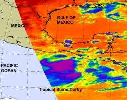
his infrared satellite image of Darby was captured from NASA's Aqua satellite on June 22 at 19:23 UTC (3:23 p.m. EDT). There is a large area of strong convection (purple) to the north of Darby's center where cloud tops were as cold as or colder than -63 degrees Fahrenheit. Credit: NASA JPL, Ed Olsen
The fifth tropical depression of the Eastern Pacific Ocean hurricane season developed and quickly strengthened into Tropical Storm Darby during the early morning hours of June 23. NASA's Aqua satellite captured a large area of strong convection that indicated that speedy strengthening.
Darby formed off the western Mexico coast south of the Gulf of Tehuantepec. At 5 p.m. EDT on June 22 Darby was located about 540 miles south-southeast of Salina Cruz, Mexico. That's near 11.5 North and 94.0 West.
Earlier on June 22, at 19:23 UTC (3:23 p.m. EDT), NASA's Aqua satellite flew over the low pressure area that became classified as Tropical Depression Darby and provided forecasters with a look at the convection happening in the storm. Infrared satellite imagery from the Atmospheric Infrared Sounder (AIRS) instrument indicated a large area of strong convection to the north of Darby's center where cloud tops were as cold as or colder than -63 degrees Fahrenheit. Infrared satellite data is helpful to forecasters in determining the convection (rapidly rising air that condenses and forms clouds and thunderstorms). Strong convection, like that seen in Darby is indicative of a strengthening tropical cyclone.
Darby's maximum sustained winds had increased to 40 mph with higher gusts by 5 a.m. EDT on June 23. Tropical storm-force winds extend outward up to 50 miles to the west of the center. Additional strengthening is also expected in the next 48 hours. Estimated minimum central pressure is 1005 millibars.
Darby is moving to the northwest near 9 mph, but is expected to turn toward the west-northwest and then west over the next day. Residents from Acapulco north to Manzanillo, Mexico should watch the track of Darby over the next several days.
Provided by NASA's Goddard Space Flight Center


