System 92L's chances for development are waning

Satellite imagery captured a visible look at System 92L earlier today, and it seems to be running into an environmental road block: upper level winds that are lessening its chances for development into a tropical cyclone.
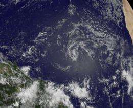
The Geostationary Operational Environmental Satellite called GOES-13 captured a visible image of System 92L on June 15 at 11:45 UTC (7:45 a.m. EDT). The GOES-13 visible image showed the low as a swirl of clouds far north of eastern Brazil and about 1,100 miles east of the Lesser Antilles. The showers and thunderstorms associated with the low have become limited this morning. System 92L continues moving west-northwestward at about 15 mph.
The National Hurricane Center noted that "Environmental conditions are expected to become less favorable for tropical cyclone formation during the next day or so." Therefore, the potential for development has decreased and the chances for development into a tropical cyclone in the next 48 hours have dropped from 50 percent yesterday to 30 percent today.
GOES-13 was launched by NASA and is now operated by the National Oceanic and Atmospheric Administration (NOAA). NASA's GOES Project at the Goddard Space Flight Center in Greenbelt, Md. created the latest satellite image that shows System 92L in its weakening state.
Meanwhile, in the Eastern Pacific Ocean, forecasters continue to watch two areas for potential tropical cyclone development.
The first area is a low pressure area that has been nearly stationary about 350 miles west-southwest of Acapulco, Mexico. Because environmental conditions are expected to continue to allow for slow development (warm sea surface temperatures and light vertical wind shear), there's still a 30 percent chance this low could develop into a tropical cyclone in the next 48 hours.
The second area has an equally low chance of developing into a tropical cyclone in the next 48 hours. It's a broad area of low pressure near the Gulf of Tehuantepec that continues to produce widespread cloudiness and thunderstorms.
Provided by NASA's Goddard Space Flight Center


