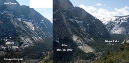
ONCE EVERY FEW DECADES: A large rockfall like this March 28, 2009, event occurs rarely in Yosemite. (Note the large swath of rock between the strands of trees in the right-hand photo.) Zimmer and her team were lucky enough to capture the event, recording seismic and acoustic data from start to finish. PHOTO COURTESY VALERIE ZIMMER, DAN KOCEVSKI AND GREG STOCK
(PhysOrg.com) -- Falling rock shatters the tranquillity of Yosemite National Park about every 10 days, and occasionally leads to fatalities. What forces trigger a rockfall? Are there precursor signals that one is imminent? Research at Yosemite by geoengineering Ph.D. student Valerie Zimmer and fellow scientists could make it possible to predict when and where rockfalls are likely to occur.
About every 10 days, falling rock shatters the tranquillity of Yosemite National Park. Bouncing boulders. Streams of granite scree. Cliffs slumping to the valley floor.
“It’s a dynamic place,” says park geologist Greg Stock. “Rockfall is the most powerful geologic force acting on the park today.” As the recent spate of earthquake and volcanic activity around the world demonstrates, the Earth is anything but static.
Yet in Yosemite, car accidents carry a greater risk of injury or death than rockfalls. Between 1851 and 2006, there have been 159 fatalities associated with motor vehicle accidents compared with 15 fatalities due to rockfalls and other geologic events. For perspective, three to four million people visit the park annually.
Still, “we want to prevent every fatality,” Stock says. “The goal is to eventually predict rockfalls and better constrain the hazard,” he says, a hazard threatening not just national parks and other managed natural areas but also roads, dams, tunnels, reservoirs and other key infrastructure.
Yosemite officials know certain areas of the park are more susceptible to rockfalls than others. But what specific forces trigger a rockfall? Is it a spontaneous event or caused by physical behavior? Most important, are there precursor signals that a rockfall is imminent? Since the planet’s formation, rock has been falling, yet its mechanics are little understood by geoscientists and engineers.
Enter Valerie Zimmer, a Berkeley geoengineering Ph.D. student. Zimmer earned her bachelor’s degree in civil and environmental engineering from Princeton with a concentration in geological engineering and worked in Wyoming’s oil fields and in the mountains of Vermont and New Mexico before arriving at UC Berkeley in 2005.
“I belong in the mountains,” Zimmer says. The Vermont native is an all-around mountaineer, in her spare time hiking, backpacking, climbing icefalls, camping in the snow, whitewater kayaking and backcountry skiing. Advised by CEE professor Nick Sitar, she launched her doctoral work studying rockfall in mines using tiny acoustic sensors to document the rock mechanics and geophysical forces underground.
When rock breaks, seismic energy is released, and waves propagate through the rock, Sitar explains. “If there’s a way to identify those releases of energy and classify them, we might be able to pinpoint areas more likely to fail,” he says.
A United States Geological Survey employee noticed Zimmer’s work and mentioned it to Greg Stock. Working on a comprehensive rockfall research program for Yosemite, Stock wanted to monitor the geological activity of the valley’s surrounding cliffs.
He was also hunting for precursor events. Park visitors have occasionally reported hearing noises prior to a rockfall: sharp cracking like a gunshot or low rumbling like thunder. “What we think is happening is that fractures are propagating through the cliff,” Stock says. “Minutes, hours or sometimes weeks later, there’s a rockfall in the area. We’d like to know exactly where the sounds are coming from and how they’re changing through time.” He called Zimmer.
Together, the two researchers developed a seismic and acoustic monitoring system at one rockfall-prone location using high-frequency triaxial 4.5-Hz geophones, triaxial accelerometers and infrasound microphones. To set up the field studies, Zimmer and her friends installed two monitoring stations on the valley floor, then scrambled up cliff sides carrying heavy equipment to install two additional stations on exposed ledges. Zimmer left the system in place from late fall through May, returning every few weeks to collect data.
Her system captured many minor events, but on March 28 last year, 43,000 cubic meters of rock fell from Ahwiyah Point near Half Dome, plunging 1,800 feet and registering magnitude 2.4 on seismic scales. It crushed hundreds of trees and wiped out a portion of Mirror Lake Trail.
“Yosemite experiences a rockfall that size every few decades,” Stock explains. No one was hurt, and Zimmer’s monitoring system captured the dramatic event from start to finish, one of the world’s richest datasets on a large rockfall.
Still analyzing her data, Zimmer has yet to draw conclusions, but of the Ahwiyah rockfall, she says, there was no precursor event observed in the seismic data.
“One day, I believe it will be possible to predict rockfalls and give people time to get out and close trails,” she adds. “But we won’t be able to predict them 100 percent of the time.”
If they secure more funding, Zimmer and Sitar want to develop a more sophisticated acoustic monitoring system to observe precursor activity. Yosemite’s granite cliffs guard their secrets, but Berkeley’s researchers, along with Greg Stock, say their project is major proof of concept, demonstrating that rockfall research affords solid ground for advancing science and reducing risk.
More information: Yosemite National Park - www.nps.gov/yose/index.htm
Provided by University of California - Berkeley


