Tropical storm Omais weakens and doubles in size

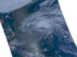
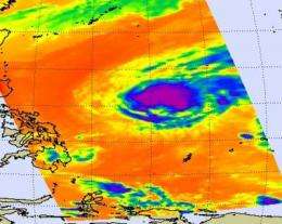
Tropical storm Omais has run into wind shear in the northwestern Pacific Ocean, but as it has weakened overnight it has also doubled in size. NASA's Aqua satellite has captured both infrared and visible images early this morning of the larger Omais.
Late yesterday, March 24, Omais strengthened to (63 mph) 55 knots and now that it has run into an environment with stronger wind shear, it has already weakened. The wind shear has increased because of the approach of a frontal system which is currently about 215 nautical miles northwest of the storm.
This morning at 0900 UTC (5 a.m. EDT) Omais' maximum sustained winds were down to 52 mph (45 knots). Omais, known in the Philippines as "Agaton," is now about 515 miles north-northwest of Palau, Micronesia, near 15.3 North and 131.5 East. It's a slow moving storm, creeping along at 5 mph (4 knots) in a north-northwesterly direction.
As the storm continues to weaken, the reach of its tropical storm-force winds is expanding over a larger area. On March 24, tropical storm-force winds of 39 mph extended 30 miles out from the center. Now that Omais has weakened winds of that same strength extend as far as 65 miles from the center, so the area of tropical storm-force winds has more than doubled overnight.

The Atmospheric Infrared Sounder (AIRS) instrument on NASA's Aqua satellite captured cold thunderstorm cloud tops in the center and southwestern corner of Tropical Storm Omais on March 25 at 12:41 a.m. EDT. The cluster of high thunderstorms on the southwestern edge is easily seen in today's AIRS visible image, as are the clouds associated with the cold front to the northwest of Omais.
As the cold front approaches, cooler and drier air associated with it will prevent cloud formation (and thunderstorm development), and vertical wind shear will increase. As a result, Omais is expected to dissipate over the next day and a half.
Provided by NASA's Goddard Space Flight Center


