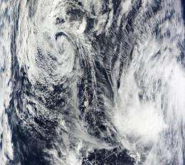
The MODIS instrument on NASA's Terra satellite captured an image of Tropical Depression Nida (top left) on December 3 at 1:35 UTC and System 97W (bottom right). Credit: NASA MODIS Rapid Response
NASA's Terra and Aqua satellites flew over Tropical Depression Nida and System 97W in the Western Pacific Ocean and noticed that one is fading while the other is powering up.
The Moderate Imaging Spectroradiometer or MODIS instrument that flies on NASA's Terra satellite captured a visible image of the two storms in one satellite pass. Nida still had a swirl to its clouds although the system has continued to weaken. On the visible imagery, System 97W currently appears as a rounded area of clouds with no established center.
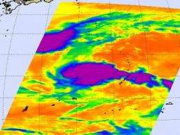
The Atmospheric Infrared Sounder or AIRS instrument captured an infrared snapshot of both storm's cold cloud tops in one image. That provided more detail about the storms, showing Nida as elongated from southwest to northeast, indicating that the storm is coming apart. The infrared imagery also showed System 97W as a rounded area, indicating a strengthening circulation.
On December 3 at 0300 UTC, the Joint Typhoon Warning Center issued its final advisory on Tropical Depression Nida. Nida had maximum sustained winds down to 28 mph (25 knots), and was still crawling along at 4 mph to the northwest. It was located about 450 miles southeast of Kadena, near 21.6 North latitude and 134.2 East longitude.
This infrared image from AIRS shows Nida fading top left (in purple and blue) on Dec. 2 at 16:11 UTC (11:11 a.m. ET) and System 97W developing (bottom right). The highest, coldest, thunderstorm cloud tops are in purple (as cold as -63F). Credit: NASA JPL, Ed Olsen
Animated multispectral satellite imagery indicated that the low level circulation center, the storm's core, was fully exposed, and didn't show any strong convection. Convection is important because it's rapidly rising air that promotes the development of thunderstorms that power a tropical cyclone. It's like a car without gasoline, it's not going anywhere. Another thing that's leading to Nida's demise is cool, dry air moving into the edges of the storm. Because of dry air, wind shear and an open center, Nida is expected to last only another 24 hours.
As Nida fades, System 97W is getting organized. Earlier today, December 3, System 97W's center was located about 110 nautical miles west of Guam, near 13.6 North latitude and 142.9 East longitude. Currently, its maximum sustained winds are around 28 mph, and it is moving away from Guam in a west-northwesterly direction near 10 mph. Current estimated minimum central pressure from the system is around 1002 millibars. The storm is also moving into a better atmospheric environment, which will allow it to strengthen.
The Joint Typhoon Warning Center noted that the "Likelihood of tropical cyclone formation is good."
Source: NASA/Goddard Space Flight Center


