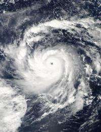
The MODIS instrument on NASA's Aqua satellite captured a visible image of Super Typhoon Nida early on Nov. 25 that shows a perfectly symmetrical storm and a clear eye, both hallmarks of a powerful typhoon. Credit: NASA MODIS Rapid Response Team
Typhoon Nida is in a favorable environment that has enabled it to intensify faster and stronger than previously forecast, and has now exploded into a Super typhoon. NASA's Aqua satellite passed over Nida and captured a visible image of the storm revealing a clear eye, which indicates a strong typhoon.
The Moderate Imaging Spectroradiometer or MODIS instrument that flies aboard NASA's Aqua satellite captured a visible image of Super Typhoon Nida on November 25 at 0355 UTC (November 24 at 10:55 p.m. ET). The image clearly revealed an eye that showed the surface of the northwestern Pacific Ocean! The MODIS image showed a tightly circulating symmetrical hurricane form.
At 10 a.m. ET on November 25, Super Typhoon Nida had maximum sustained winds near 172 mph (150 knots) with gusts as high as 207 mph! A category five typhoon on the Saffir-Simpson scale has sustained winds greater than 155 mph. Typhoon-force winds extend as far as 45 miles from Nida's center, while tropical storm-force winds extend out as far as 105 miles from Nida's center.
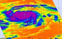
NASA's Aqua satellite captured a clear eye and cold, powerful thunderstorm cloud tops (colder than -63F) in Nida in this infrared image Nov. 25 at 0347 UTC. Nida is a Category 5 storm with sustained winds near 172 mph. Credit: NASA JPL, Ed Olsen
Nida was about 155 miles west-southwest of Guam, near 12.6 North latitude and 142.2 East longitude. It was moving to the northwest near 15 mph, and its powerful winds were kicking up dangerously high waves up to 44 feet high!
Fortunately, no landmasses are directly threatened by Nida, although today, Nida is passing between the island of Yap and Andersen Air Force Base. Those islands will experience heavy surf to their northeastern and southwestern sides, respectively. The Joint Typhoon Warning Center noted that Nida can strengthen even further as it is going to track over very warm sea surface temperatures in the next day.
Nida is forecast to remain in open waters over the next 5 days and is expected to pass far to the southwest of the island of Iwo Two on Monday, November 30.


