Papahanaumokuakea National Monument facing Hurricane Neki

A hurricane warning is in force for the Papahanaumokuakea National Monument from Nihoa Island to French Frigate Shoals to Maro Reef. Hurricane conditions likely there by 5 a.m. HST on Friday, October 23.
The Papahānaumokuākea Marine National Monument is the single largest conservation area under the U.S. flag, and one of the largest marine conservation areas in the world. It encompasses 139,797 square miles of the Pacific Ocean (105,564 square nautical miles) - an area larger than all the country's national parks combined.
Many of the islands and shallow water environments in the National Monument are important habitats for rare species such as the threatened green sea turtle and the endangered Hawaiian monk seal.
As Hurricane Neki nears, the storm had maximum sustained winds near 115 mph at 5 a.m. HST (11 a.m. EDT) today, October 22. It was located about 245 miles south of French frigate shoals and 525 miles west of Honolulu, Hawaii, near 20.4 North and 166.0 West. Neki was moving north-northeast near 10 mph, and had a minimum central pressure of 965 millibars.
Neki's hurricane force winds extend outward up to 60 miles from the center, and tropical storm force winds extend outward up to 205 miles.
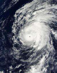
NASA's Terra satellite passed over Neki and captured an image of the large storm using the Moderate Imaging Spectroradiometer (MODIS) instrument on October 21 at 2145 UTC (5:45 p.m. EDT/11:45 a.m. HST local time).
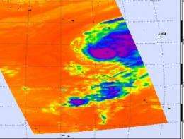
NASA Aqua satellite also took a look at Neki, and measured the storm's thunderstorm cloud-top temperatures using infrared imagery. The Atmospheric Infrared Sounder (AIRS) instrument showed some high thunderstorm tops in Neki indicating heavy rainfall and strong convection. Those cloud temperatures were colder than minus 63F.

High seas are a concern with Neki. Neki is creating high seas of 15 to 20 feet that will build up across the smaller islands of the Papahanaumokuakea National Monument. For more information about the Papahanaumokuakea National Monument, visit: http://papahanaumokuakea.gov/
Little change in Neki's strength is forecast over the next 24 hours, but Neki is expected weaken as the storm heads into cooler waters and wind shear. Neki is forecast to continue moving northeast and then weaken to a depression by early next week.


