The naked truth about our landscape

Australia has been stripped bare of vegetation to expose the surface that lies beneath.
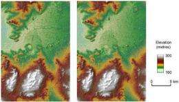
Scientists from CSIRO's Water for a Healthy Country Flagship have removed approximately 90 per cent of Australia's vegetation cover from satellite images of the continent to produce the most detailed available Digital Elevation Model (DEM) of its topography.
"The DEM will revolutionise geological applications, land-use studies, soil science, and much more," CSIRO's Dr John Gallant said in an address today to the Spatial Sciences Conference in Adelaide.
"Produced at a one-second resolution - about 30 metres - the DEM exposes intimate details about Australia's landscape features. As a result, we can now clearly make out the shape of our landscape and understand how water might move across its surface, how it came to be its present shape and how variable our soil terrains are."
Since releasing the Digital Surface Model (DSM) last year, the new vegetation removal process has also resulted in a 'spin-off' vegetation height map that may be useful for calculating biomass and contributing to carbon accounting.
The DEM will provide a body of information related to water resources and is a key activity within the water information research and development alliance between the Flagship and the Bureau of Meteorology's 'Improving Water Information Program'.
The final phase of building the one-second resolution DEM will occur over the next year with the inclusion of Australia's river network to produce a drainage-enforced DEM that will assist the Bureau to generate water accounts for the continent.
The DEM is based on the Shuttle Radar Topographic Mission (SRTM) satellite data collected by NASA during its Space Shuttle mission in 2000.
The one-second DEM dataset is licensed and managed by project collaborator, Geoscience Australia, and will be available from mid-November to all tiers of Australian government. A three-second version (approximately 90 metres) of the DEM will eventually be available for public use.


