NASA's Aqua satellite gets two views of category 4 Hurricane Bill

Hurricane Bill has become a powerhouse in the Atlantic Ocean and NASA satellites are providing forecasters with important information to help their forecasts. Bill is now a category four hurricane on the Saffir-Simpson Scale and is expected to strengthen as it nears Bermuda, and NASA's Aqua satellite captured two views of his cloud cover.
On Wednesday, August 19, at 5 a.m. EDT, Bill's maximum sustained winds are near 135 mph, and hurricane force-winds extend out to 45 miles from Bill's large 35-45 mile-wide eye. Bill was closing in on the Leeward Islands, about 460 miles east of them, near 18.0 degrees north latitude and 54.9 west longitude. Bill continued to move west-northwest at 16 mph and had a minimum central pressure near 948 millibars.
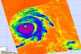
NASA's Atmospheric Infrared Sounder (AIRS) instrument on the Aqua satellite captured Hurricane Bill's cold clouds with infrared imagery on August 18 at 12:35 p.m. EDT. The infrared revealed very cold high clouds, indicating strong thunderstorms and a powerful hurricane. Infrared imagery is useful to forecasters because it shows the temperature of the cloud tops, helping recognize if powerful thunderstorms exist in the storm. AIRS infrared imagery showed Bill's thunderstorm clouds are cold as or colder than 220 Kelvin or minus 63 degrees Fahrenheit (F)!

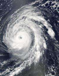
Meanwhile, the Moderate Imaging Spectroradiometer, or MODIS instrument on Aqua satellite captured a stunning image of Hurricane Bill on August 18 at 2:40 p.m. EDT, clearly showing his large eye.
Bill's track has been the question on the minds of U.S. East Coast residents, and currently the models are indicating two different scenarios. According to the National Hurricane Center discussion this morning, August 19, "The track guidance models forecast Bill to gradually turn northwestward towards this weakness during the next 48-72 hours."
There's a large "deep-layer trough" - an elongated area of low pressure, associated with a cold front that is moving into the eastern United States, and forecasters think that front is going to push Bill eastward and curve him north and northeastward. Bill's track depends on the strength of the front and the timing, so one model calls for Bill to go near New England while other computer models have him taking a sharp turn out to sea. Forecasters and East Coast residents are hoping the front pushes Bill out to sea.
Source: NASA/Goddard Space Flight Center


