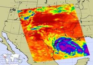
Image credit: NASA/JPL
Tropical Storm Erin quickly weakened to a tropical depression when she made landfall on the Texas coast near Lamar during the early morning hours of Thursday, August 16, 2007.
At 7:00 a.m. CDT the tropical storm warning for the Texas coast was been discontinued. At that time, the center of Tropical Depression Erin was located near latitude 28.0 north and longitude 97.2 west, near Lamar, Texas. That's about 25 miles northeast of Corpus Christi, Texas.
Maximum sustained winds have decreased to 35 mph with higher gusts. The depression should continue to weaken as it moves over land today. Estimated minimum central pressure is 1006 millibars. The depression is moving toward the west-northwest near 12 mph and this motion is expected to continue, bringing the center farther inland today.
Total rain accumulations of 3 to 6 inches are expected across much of central and southern Texas with possible isolated maximum amounts of 10 inches. Isolated tornadoes are possible near the middle Texas gulf coast today.
On Thursday the local forecast for Corpus Christi, Texas includes a flash flood watch, as Erin's showers and thunderstorms could produce heavy rains. A forecast high of 86F is expected with a heat index to 98F. Southeast winds will blow between 20 and 26 mph, and gusts to 32 mph. Showers and thunderstorms will continue through Saturday until the evening hours, when Erin's remnants will be west of the area.
In this infrared image from August 15, created by data from the Atmospheric Infrared Sounder on NASA's Aqua satellite, Tropical Storm Erin lurks off the Texas coast. This AIRS image shows the temperature of the cloud tops or the surface of the Earth in cloud-free regions. The lowest temperatures (in purple) are associated with high, cold cloud tops that make up the top of the hurricane. The infrared signal does not penetrate through clouds. Where there are no clouds the AIRS instrument reads the infrared signal from the surface of the Earth, revealing warmer temperatures (red). This infrared image shows large areas of strong convection surrounding the core of the storm (in purple).
Source: NASA


