By Friday, August 24, 2007, the remnants of Dean were dissipating off the western Mexican coast.
Dean, who slammed into the Yucatan Peninsula as a mighty Category 5 hurricane on the Saffir-Simpson scale, moved into the Gulf of Campeche and made a second landfall in Mexico as a Category 2 hurricane is now a bad memory.
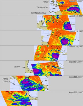
This is a series of infrared images shown above of Hurricane Dean from August 17-23, created by data from the Atmospheric Infrared Sounder on NASA's Aqua satellite. These AIRS images show the temperature of the cloud tops or the surface of the Earth in cloud-free regions. The lowest temperatures (in purple) are associated with high, cold cloud tops that make up the top of the hurricane. The infrared signal does not penetrate through clouds. Where there are no clouds the AIRS instrument reads the infrared signal from the surface of the Earth, revealing warmer temperatures (red). This infrared image shows large areas of strong convection surrounding the core of the storm (in purple).
In this first AIRS satellite image from August 17, 1:48 p.m. EDT (17:48 UTC), Dean had just passed over the Lesser Antilles and was moving westward. In the second AIRS image on August 18, at 2:29 p.m. EDT (18:29 UTC) Dean is shown as the purple area on the right side of the image (box), and Dean's clouds, winds and rain are covering Haiti and the Dominican Republic, while Jamaica lies in Dean's path.
The third image, from August 19 at 2:41 a.m. EDT (06:41 UTC) shows Dean due south of Cuba, and his eye was clearly visible. A visible eye is an indication of a strong storm. At this time, Dean was a Category 4 hurricane on the Saffir-Simpson scale. The fourth image is from Monday, August 20, 2007 at 3:23 a.m. EDT (7:23 UTC) showing Dean moving westward and closing in on the Yucatan Peninsula.
Dean's first landfall was as a powerful Category 5 hurricane with maximum sustained winds of 165 mph. After barrelling through Mexico's Yucatan Peninsula, a weakened Hurricane Dean emerged into the Gulf of Mexico in the fifth image taken August 21 at 2:59 p.m. EDT (1859 UTC). Dean was expected to regain some strength before making landfall again in central Mexico.
Dean's second landfall occurred near Tecolutla, Mexico. At that time, Dean was packing maximum sustained winds of 100 mph. That made Dean a Category 2 hurricane on the Saffir-Simpson scale. Weaned from its strength-giving source of energy over the Gulf of Mexico's warm waters, Hurricane Dean, downgraded to a tropical storm in this sixth image from August 22 at 3:41 p.m. EDT (19:41 UTC), moves into southern and central Mexico.
The final image from NASA's AIRS instrument taken Thursday, August 23 at 4:23 p.m. EDT (20:23 UTC) shows the remnants of Dean off the southwestern coast of Mexico (blue).
Source: by Rob Gutro, NASA Goddard Space Flight Center


