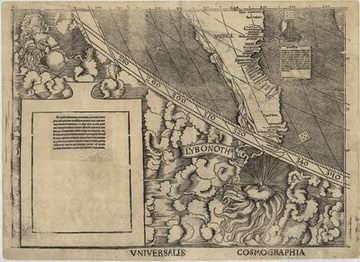
This sheet (bottom) from the lower left corner of the 12 that make up the Library of Congress’ Waldseemüller map marks the first time the word "America" was used for the newly discovered lands. The full map also shows the outline of North and South America, as well as the Isthmus of Panama, and was the first to depict clearly a separate Western Hemisphere, with the Pacific as a separate ocean. Credit: Library of Congress
What does the Library of Congress (LOC) do when it wants to preserve a 500-year-old map, the only known copy of the first world map to call America “America?”
To preserve the document sometimes called “America’s Birth Certificate,” the Library has partnered with the National Institute of Standards and Technology (NIST) to design a hermetically sealed encasement for the 12-sheet 1507 Waldseemüller map.
The encasement is designed to provide optimum accessibility for the public while preserving and securing the document. NIST will supervise the construction of the case, which will be turned over to the Library in 2007. The Library will display the map in the fall of 2007 as part of its “New Visitors’ Experience” exhibit.
NIST designed and built the encasements that today house America’s Charters of Freedom—the Declaration of Independence, the Constitution, the Bill of Rights and their transmittal letters—for the National Archives in 2003. The Waldseemüller map encasement would be almost six times bigger than the largest previous case (for the Bill of Rights).
The planned NIST/Library design calls for the case to be machined from a solid piece of aluminum and sealed with an anodized aluminum frame and a sheet of laminated, non-reflective glass. The finished case will measure 116 in. by 73 in. by 4 in. (295 cm by 185 cm by 10 cm). The hermetically sealed encasement will include valves for flushing out oxygen (which chemically reacts and degrades organic material such as the map’s paper and ink) and filling the encasement with inert argon gas. The encasement also will contain monitoring devices to measure internal environmental conditions.
The design, fabrication and testing of the encasement are largely funded through the Waldseemüller Support Fund, established by Virginia Gray and the Gray Family in memory of Martin Gray, with additional support from The Alcoa Foundation, for the encasement fabrication and instrumentation, and the Alcoa Company, which will donate the monolithic aluminum blocks from which the various encasement components will be fabricated.
The Library of Congress acquired Waldseemüller’s 1507 world map in 2003 from the family of Prince Johannes Waldburg-Wolfegg of Wolfegg, Germany. The map was drawn by cartographer Martin Waldseemüller and others in St. Dié, France and depicts European geographic discoveries of the late 15th and early 16th centuries, including those based on data collected by Amerigo Vespucci during his voyages to America. Vespucci’s explorations, especially along the east coast of South America, convinced him that Columbus’ “Indies” was a new continent. In his map, Waldseemüller named the newly discovered continent “America” in Vespucci’s honor. Later cartographic efforts by Waldseemüller referred to the Western Hemisphere as “Terra Incognita” or “Terra Nova.” Too late—the first name had already caught on.
Source: NIST


