Understanding Earthquakes
Rensselaer campus regulars may not be aware of it, but earthquakes frequently surge through the basement of the Jonsson Engineering Center, the seemingly placid engineering building overlooking the school’s football field. Producing a powerful shaking, these seismic events have taken a considerable toll, leaving behind a litany of broken pipes, damaged pilings, and other serious structural problems.
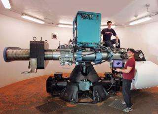
Image above: The 150 g-ton geotechnical centrifuge NEES facility is located in the basement of the Jonsson Engineering Center of the Rensselaer campus in Troy, N.Y.
Not to worry, though. The earthquakes in question are actually scale-model simulations, generated by civil engineers in Rensselaer’s recently redeveloped Geotechnical Centrifuge Center, part of the George E. Brown Jr. Network for Earthquake Engineering Simulation (NEES), a nationwide academic research consortium. The tests often use Rensselaer’s state-of-the-art centrifuge itself, an imposing device with a mechanical arm that can swing model structures around at 250 miles per hour, exerting forces real buildings would face only at catastrophic moments.
“We cannot wait 20 or 30 years for an earthquake to occur,” says Ricardo Dobry, professor of civil and environmental engineering and director of the Geotechnical Centrifuge Center. “This allows us to test structures and full systems.” Recent natural disasters — particularly the December 2004 earthquake and tsunami originating in Sumatra and the October 2005 earthquake in Pakistan, which have killed thousands — only underscore the importance of research in these areas.
Indeed, while Troy itself, like all of New York state, rarely experiences significant seismic activity, Rensselaer is a hive of research activity on the subject. University researchers are at the leading edge of studying both the causes and the effects of earthquakes, examining everything from the physical construction of fault zones to the preferred construction of buildings in those zones.

And the Geotechnical Centrifuge Center is just one node of earthquake research at Rensselaer. University earth scientists have fanned out across the globe to perform significant fieldwork for years, studying faults and earthquake activity from Kyrgyzstan to California, and from Indonesia to Oregon. Rensselaer research on earthquakes also engenders interdisciplinary projects: Engineers work with computer scientists, and geophysicists collaborate with mathematicians. All told, earthquakes may be an age-old problem, but the research methods Rensselaer faculty use to understand them are distinctly new.
Earth Moves
Earthquakes are a product of the motion of the planet’s tectonic plates — the 20 or so large segments of the Earth’s crust slowly moving around the globe, which are responsible for the ongoing rearrangement of the world we see. A head-on collision between tectonic plates, which has happened at the edge of the Indian sub-continent, can produce spectacular features such as the Himalaya mountain range and the Oct. 8 Kashmir earthquake.
Tectonic plates do not always meet in this precise fashion, however. When a plate largely supporting an ocean meets a continent-bearing plate, the heavier oceanic plate tends to dive underneath its neighbor, in the process called subduction. And sometimes plates scrape past one another in a lateral motion, as is the case with the San Andreas Fault in California.
Whatever the precise movement, a single earthquake represents the release of tension that accumulates along a fault, where plates move in fits and starts. “It’s like a spring getting loaded,” says Rob McCaffrey, professor of geophysics at Rensselaer, who has helped pioneer the use of Global Positioning System (GPS) technology to measure the movements of plates. “The number one question is how much of the fault will go at one time,” McCaffrey adds. “That determines the magnitude of the earthquake and the duration of its shaking.”
In geologic time, spanning billions of years, an individual earthquake is a tiny, incremental event. In human terms, however, as Dobry notes, major earthquakes are infrequent (although small ones happen every day around the globe). Yet that is only one reason engineers need to generate their own steady stream of data through simulated quakes.
“With earthquakes, another big problem is, you never know when or where they’re going to happen,” adds Tarek Abdoun, assistant professor of civil engineering at Rensselaer and associate director of the Geotechnical Centrifuge Center. As Abdoun and his colleagues observe wryly, “Whenever you put instruments in a certain area, earthquakes never happen there. But for us, as engineers, to be able to understand a certain phenomenon and design for it, you need to know what is happening. With a centrifuge, you have instrumentation, you can recreate the event, you learn a lot, and now you can improve the design and the foundation of buildings.”
Besides, the sheer scale of the planet means researchers are still beginning to collect earthquake data in many places. In the 1980s, McCaffrey was among the first scientists to use GPS measurements in Indonesia, where the 2004 Sumatra earthquake was located. Today, much of McCaffrey’s work involves “measuring the buildup of the energy right now” in complex fault systems, in order to develop a detailed picture of fault activity and, eventually, a better sense of which fault segments might be most prone to move in a given period.
Specific earthquake predictions, though, remain an elusive goal. The outlines of tectonic plates might look simple on a world map, but the view from the ground is another matter. Within a fault zone itself, tectonic plates do not just neatly collide or grind past one another, but can shatter into smaller pieces, like a fractured eggshell. The more scientists measure subduction zones, the more they realize how complicated they can be — especially in places like Sumatra.
“It’s not just a simple subduction,” says McCaffrey, who over the years has become something of a specialist in such regions, including Oceania and the Pacific Northwest of the United States. “What New Zealand and Cascadia and Sumatra have in common is that the upper plate in the system is breaking apart and forming these little plates that are moving around independently.” Oregon, by way of illustration, sits on a small plate rotating clockwise relative to the rest of the United States. Such intricacies make charting the mechanics of a fault zone almost exponentially harder.
Journey to the Center of the Earth
Then again, Rensselaer earth scientists seem drawn to hard cases. “The fact that the Earth is complicated, well, that’s what you have to deal with,” says Steve Roecker, Rensselaer professor of earth and environmental sciences. Roecker is undertaking multiple projects designed to help reveal, case by case, what substances lie underneath faults, and how these materials relate to their motion.

Roecker spent the summer of 2005 in Kyrgyzstan, studying the Tien Shen mountains — a geologic puzzle since they exist not at the edge of a tectonic plate but in the middle of one, the Eurasia Plate. “The real mystery is why there are mountains there at all,” acknowledges Roecker. Among other possibilities, there could be a large fault covered up by the Tien Shen mountains, or a series of smaller fractures near the Earth’s surface that act like miniature plate boundaries.
To study the Earth’s insides, Roecker sets up networks of seismometers — sensitive measuring devices — and records the speed of the waves generated by earthquakes. For a geophysicist, this data reveals much about the materials lying underground: High-temperature rocks, for instance, slow down earthquake waves. Moreover, technological advances this decade now allow small seismometers to pick up waves originating far away. “We’re able to make some nice pictures just by setting up instruments and waiting for an earthquake to happen anywhere in the world,” says Roecker.
For the Tien Shen project, those pictures may involve the Earth’s mantle, the viscous layer underneath the crust that ranges roughly 20 to 2,000 miles below the Earth’s surface. By contrast, in California, Roecker is part of a project called the “San Andreas Fault Observatory at Depth,” an attempt to drill just a couple of miles into the Earth’s surface. Scheduled for completion in 2006, it aims to reveal what substances enable plates to slip and slide past one another (underground water is a prime suspect).
Roecker’s efforts to turn the data into maps of the Earth’s interior, at any depth, are often conducted with colleagues at Rensselaer’s Inverse Problems Center (IPRPI), including mathematicians Margaret Cheney and Joyce McLaughlin, who have years of relevant experience from analogous areas like medical imaging. “They have a very fundamental understanding of these techniques,” says Roecker. Ultimately, he says, “the idea is to try to connect the stuff at the surface, like mountain-building, with the forces driving it beneath the surface.”
Interdisciplinary Research
Understanding the composition of the Earth in a fault zone also happens to be where geophysicists and civil engineers find common ground, so to speak. The ground a building stands on has an enormous impact on the stability of that structure. In an earthquake, soft areas like landfill often undergo the phenomenon of “liquefaction,” the Jello-like shaking that dramatically increases the chances of a building collapse.
Thus, when engineers in the Geotechnical Centrifuge Center conduct tests, they do not merely expose a structure to a powerful force, but examine how that structure will react in certain ground conditions.
Consider pilings under a building, or pipes running through the ground. Near the surface, the Earth creates little stress. But further down, the stress increases. The centrifuge can mimic those stresses — either as a catastrophic event or an accumulation of stress over time — and tell engineers if their structures will pass muster.
A typical test in the Rensselaer centrifuge might have a length of pipe embedded in a mix of soil, on a tray fixed to the whirling arm of the machine. The pipe will be heavily wired with sensors transmitting information for analysis. “The interaction between the soil resisting and the building pushing in, that’s what creates the actual response,” says Abdoun.
Indeed, the roots of the Geotechnical Centrifuge Center go back to soil studies Dobry and Thomas Zimmie, another professor of civil engineering at Rensselaer, started pursuing in the 1970s. In the late 1980s, Rensselaer acquired the centrifuge. A decade later, spurred on by the National Science Foundation, a new idea in earthquake research took hold: Forming the NEES as a network of linked labs. “The information revolution was in full swing, and the emphasis changed,” says Dobry. “Instead of upgrading a bunch of separate earth engineering centers around the country, the idea became to build an integrated national laboratory.”
Backed by NSF funding for refurbishment — including $5 million covering operations over the next five years — the upgraded Geotechnical Centrifuge Center, along with the rest of the NEES, opened in the fall of 2004. The center, much more than the centrifuge, is littered with intriguing-looking equipment, including a “shake table,” a rectangular metal frame with segmented walls that can replicate seismic effects; a related octagonal tool the staffs call “the slinky;” a robot on the centrifuge that alters models while swinging around in mid-experiment; and a videoconferencing center. The staff includes computer specialists and a variety of engineers.
“As we build things in the center, we’re interacting with mechanical engineers, electrical engineers, robotic engineers, and information technologists” says Dobry. “It’s the definition of interdisciplinary research.”
Globalization of Research
Dobry believes information technology will change earthquake research profoundly, with remote sensors becoming an increasingly pervasive way of gathering data. Abdoun has developed a wireless sensor that can be lowered into the ground, and has initiated a California-based project along with Caltrans, the state transit agency, taking real-time ground movement measurements near highways. Eventually, promises Dobry, there will be “hundreds of thousands” of sensors in use, on the ground and in “the constructed environment — buildings, bridges, pipes, structures. When an earthquake happens, we will get data from the real world.”
For now, the increasingly networked nature of engineering research compensates. Rensselaer researchers are currently participating in a novel computer-simulation project, testing a bridge with faculty at two other NEES universities. The bridge’s deck is being tested at Lehigh University, its piers at the University of Illinois, the foundations at Rensselaer, and the results are shared via the NEES supercomputer in San Diego.
Similarly, Rensselaer researchers are conducting joint NSF-funded tests, along with engineers from Cornell University, of “critical lifelines” such as pipes during quakes. The Cornell researchers can produce ruptures on full-scale pipes in a large testing facility in Ithaca, but Rensselaer’s centrifuge, precisely because of its smaller scale, can subject model pipes to a greater relative range of forces. The result is a combination of data otherwise unavailable to a single group of experts.
Beyond NEES, Rensselaer engineers using their shake table share test data with researchers in Japan, who use the world’s largest shake table in a warehouse-sized facility. And along with the flow of data comes a flow of people: Visiting researchers at the centrifuge this academic year will include two experts from the Advanced Institute of Science and Technology in Korea.
This globalization of research seems a natural development in the study of a global phenomenon, and one with experts in geographically disparate regions, from Japan to Chile, Australia, and other earthquake-prone places. And, as it happens, in Troy, where research rolls on, but residents do not have to worry much about earthquakes. Even when they are in the Jonsson Engineering Center.
Source: Rensselaer Polytechnic Institute (By Peter Dizikes)


