Hurricane Katrina: Scientists Fly Into Eye of the Storm
Researchers Study Hurricane Rainbands and Eyewall
Real-time radar data and high-tech communications were the keystones to success this past weekend as the Rainband and Intensity Change Experiment (RAINEX) project began its research with Hurricane Katrina. The project is funded by the National Science Foundation (NSF).
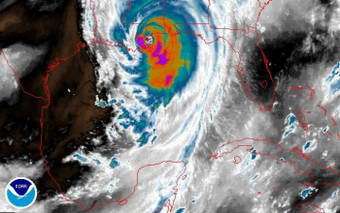
Image: Scientists from the RAINEX project flew into the edge of Hurricane Katrina on Aug. 27 and Aug. 28 to study its rainbands and the formation of its eyewall, taking simultaneous measurements from two aircraft as Katrina grew into Category 5 and bore down on the Gulf Coast. Credit: NOAA water vapor satellite image
RAINEX became the first hurricane research project to fly planes nearly simultaneously inside and outside a hurricane's principal rainband, gathering information that will help scientists to better understand changes in a hurricane's intensity.
RAINEX is studying the interaction between hurricane winds and rain, using data recorded from hurricane research flights, according to Steve Nelson, program director in NSF's atmospheric sciences division, which funded RAINEX. For six weeks of this year's active hurricane season, two research aircraft will fly simultaneously into hurricanes before the storms make landfall.
Flying in the hurricane's outer bands and eyewall on most flights, the aircraft are using sophisticated Doppler radar and Global Positioning System dropsondes to record wind speed and direction, temperature, humidity, atmospheric pressure, and other critical data.
"While the forecasting of hurricane tracks has come a long way, that kind of information results from a variety of variables external to the hurricane," says Robert Houze, an atmospheric scientist at the University of Washington and a RAINEX principal investigator. "Intensity is driven in part by internal dynamics between the rainbands and the eyewall - something that is very hard to get to - so this is landmark information that will help us to understand this phenomenon better."
Shuyi Chen, a meteorologist and physical oceanographer at the University of Miami Rosenstiel School of Marine and Atmospheric Sciences (RSMAS), also a RAINEX principal investigator, developed a fine-resolution, coupled atmosphere-wave-ocean computer model to study hurricane intensity changes. While most models estimate atmospheric activity down to tens of kilometers, her model goes further - down to a kilometer or two, filling in information gaps and providing realistic rainband and eyewall structure simulation. Researchers are able to use the model in combination with airborne Doppler radar measurements to better understand hurricane intensity changes.
"The airborne radar data come into our operations center in real-time," said Chen. "We process it, and then share it with the research planes within a few minutes. This helps the planes navigate and position themselves appropriately, and it helps us guide planes to exactly the area of the hurricane where we want to take measurements. It's the first time we have ever tried this new way of communicating from the ground to planes flying in a hurricane."
RAINEX also involves scientists from the National Center for Atmospheric Research (NCAR) in Boulder, Colo., the National Oceanic and Atmospheric Administration (NOAA), and the U.S. Navy.
Source: NSF


