Earth's gravity scar
A new ESA study predicts that the devastating Sumatran earthquake, which resulted in the tragic tsunami of 26 December 2004, will have left a ‘scar’ on Earth’s gravity that could be detected by a sensitive new satellite, due for launch next year.
The Sumatran earthquake measured 9 on the Richter scale and caused widespread devastation and death when it struck unexpectedly late last year. Thankfully, earthquakes of this magnitude are rare events, taking place perhaps once every two decades.
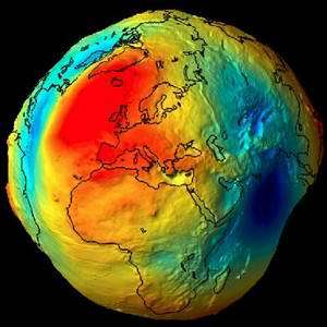
Image: The Gravity Field and Steady-State Ocean Circulation Explorer (GOCE) mission will measure high-accuracy gravity gradients and provide a global model of the Earth's gravity field and of the geoid. The geoid (the surface of equal gravitational potential of a hypothetical ocean at rest) serves as the classical reference for all topographical features. The accuracy of its determination is important for surveying and geodesy, and in studies of Earth interior processes, ocean circulation, ice motion and sea-level change.
Seismological data suggests that, during the event, the seafloor on either side of a fault line running for 1000 km along the bottom of the Indian Ocean dramatically changed height, producing a ledge, 6 metres high. Such a large-scale movement will change the gravitational field of the Earth. Roberto Sabadini and Giorgio Dalla Via, University of Milan, and colleagues have calculated this change. They found that the Earth’s gravity altered, in an instant, by as much as is expected from six years' worth of melting at the Patagonian Ice Fields in southernmost South America.
It may seem surprising that Earth’s gravity is not equally strong at all points of the globe. Instead, it varies by a small fraction due to the presence of such things as mountains or deep ocean trenches. The tides and ocean circulation patterns also affect the gravity, as does the rotation of the Earth itself, which bulges out the planet’s equator and makes its diameter 21 kilometres wider than the pole-to-pole distance.
In order to measure the deviations from the average level of gravity, Earth scientists invented the concept of the geoid. This is a bit like a hi-tech version of ‘sea level’, which is often used to give an absolute height measure. Today’s modern measurements need something more accurate, however.
The geoid is a hypothetical surface, on which the gravitational pull of the Earth is the same everywhere. It wraps itself around the Earth, moving away from the real surface when it is over areas of greater density and therefore stronger gravity. Over less dense regions, the geoid moves closer to the real surface.
When material is moved around, either instantaneously in an earthquake or gradually as in a melting ice field, the Earth’s gravity in the local region changes and so does the height of the geoid. In the Sumatran earthquake, Sabadini and Dalla Via found that the total geoid movement was some 18 mm – a lot for a geoid!
ESA’s Gravity Field and Ocean Circulation Explorer (GOCE) is designed to sensitively investigate the gravitational field of the Earth from orbit. As the spacecraft passes over regions of stronger and weaker gravitational pull, it will bob up and down. Such deviations are far below the perceptible limits of humans but GOCE is equipped with a device called a gradiometer than can detect these ultra-subtle differences. By measuring the deviations in the geoid, scientists can gain a unique window into our planet.
“This work is at the frontier of geophysics and the perfect complement to seismology,” says Sabadini, “Seismology is good for detecting the slip of earthquake faults and the location of the epicentre, geoid monitoring can determine how much mass is actually being moved around.”
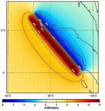
Image: The upward and downward displacement of the seafloor during the 28 December 2004 earthquake caused a change in the Earth¹s geoid. The surface moved by around six metres and this caused the geoid to change by 18 millimetres. The changes to the geoid are shown here with upward geoid movements in red and downward ones in blue. Credits: R. Sabatini, Univ. Milano
It can also be used in the quest to understand climate change as ocean circulation also affects the geoid. Changes in climate, which in turn affect the ocean circulation pattern, will show up as a yearly change in the geoid. With so much to offer, the GOCE satellite is scheduled to launch in 2006. A paper on the Sumatran Earthquake by Roberto Sabadini, Giorgio Dalla Via, Masja Hoogland, Abdelkrim Aoudia is published in EOS, the journal of the American Geophysical Union.
Source: ESA


