Satellite sees Tropical Cyclone Nathan begin circling near Queensland coast

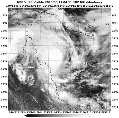
NASA-NOAA's Suomi NPP satellite captured an image of Tropical Cyclone Nathan as it was beginning to make a cyclonic loop near the eastern coast of Queensland's Cape York Peninsula on March 11.
Warnings and Watches were in effect on March 11 in Queensland Australia. A tropical cyclone warning was in effect from Coen to Port Douglas, and a tropical cyclone watch was in effect from Lockhart River to Coen. For updated watches and warnings from the Australian Bureau of Meteorology, visit: http://www.bom.gov.au/cyclone/.
When Suomi NPP passed over Nathan on March 11 at 4:11 UTC (12:11 a.m. EDT) the Visible Infrared Imaging Radiometer Suite or VIIRS instrument aboard captured a visible image of the storm. The clouds surrounding center appeared rounded in the VIIRS image indicating it had good circulation. The center was located off-shore between Cape Melville and Cape Flattery and stirring up seas along those areas. The majority of thunderstorms and convection were occurring in the storm's northern quadrant.
Forecasters at the Australian Bureau of Meteorology expect Nathan to proceed to the southwest and turn north, then northeast and east, making a cyclonic loop over the next two days. That means that Nathan will stop heading toward the Cape York Peninsula and move away from it in an easterly direction.
The Joint Typhoon Warning Center (JTWC) noted that Nathan will track to the east and intensify "due to a shortwave trough (elongated area of low pressure) passing to the south and the steering mechanism shifting to the strong westerlies."
VIIRS is a scanning radiometer that collects visible and infrared imagery and "radiometric" measurements. Basically it means that VIIRS data is used to measure cloud and aerosol properties, ocean color, sea and land surface temperature, ice motion and temperature, fires, and Earth's albedo (reflected light). The Suomi NPP mission is a bridge between NOAA and NASA legacy Earth observing missions and NOAA's next-generation Joint Polar Satellite System, or JPSS.
On Mar. 11 at 1500 UTC (11 a.m. EDT), the JTWC noted that Nathan had maximum sustained winds near 45 knots (51.7 mph/83.3 kph). It was centered near 13.4 south latitude and 146.1 east longitude, about 212 nautical miles (244 miles/392 km) north of Cairns, Queensland, Australia. It was moving to the north-northwest at 4 knots (4.6 mph/7.4 kph). Nathan formed less than 24 hours before on March 10 in the Coral Sea, Southern Pacific Ocean.
The JTWC noted that decreasing vertical wind shear and warm sea surface temperatures will allow Nathan to strengthen over the next day and a half as it continues in its cyclonic loop.
Provided by NASA's Goddard Space Flight Center


