NASA gathering data on Super Typhoon Vongfong as Japan prepares

Super Typhoon Vongfong continued on its trek north through the Philippine Sea while slightly weakening on Oct. 10. NASA's TRMM and Aqua satellites provided forecasters with cloud extent, rainfall rates and distribution and more.
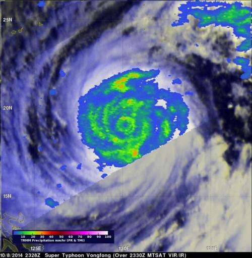
Vongfong was a super typhoon with wind maximum sustained winds of 145 knots (167 mph) when the TRMM satellite flew over on October 8, 2014 at 2328 UTC 7:28 p.m. EDT). TRMM's Microwave Imager showed that Vongfong was producing rainfall over a large area and heavy rainfall in the eye wall (the powerful thunderstorms around the open eye) and in multiple bands of thunderstorms wrapping into the center. On Oct. 8, Vongfong was the most powerful typhoon since super typhoon Haiyan that killed over 6,000 people after hitting the Philippines in November 2013.
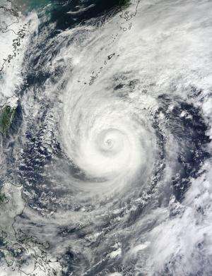
On Oct. 10 at 2:05 UTC, the Moderate Resolution Imaging Spectroradiometer or MODIS instrument aboard NASA's Terra satellite captured an image of Typhoon Vongfong in the Philippine Sea. The visible image showed that the eye had become filled with high clouds, although it maintained its symmetrical circular shape. Feeder bands of thunderstorms wrapping into the center from the north, extended over Japan's Ryukyu Islands.
On Friday, Oct. 10 at 1500 UTC (11 a.m. EDT) Typhoon Vongfong's maximum sustained winds had dropped slightly to 115 knots (132 mph/213 kph). Forecasters at the Joint Typhoon Warning Center expect winds to drop to 105 knots (120.8 mph/194.5 kph) by Oct. 11 at 1500 UTC, and 85 knots (97.8 mph/157.4 kph), by Sunday, Oct. 12 at 1500 UTC (11 a.m. EDT).
On Oct. 10 at 11 a.m. EDT Vongfong was centered near 23.5 north and 129.2 east, about 220 nautical miles (253 miles/407 km) south-southeast of Kadena Air Base, Okinawa, Japan. Vongfong was moving to the north at 8 knots (9.2 mph/14.8 kph) and generating 38-foot (11.5 meter) high seas. On Oct. 8 when Vongfong was a Category 5 typhoon, it was generating wave heights to 50 feet (15.2 meters).
Vongfong continues to slowly weaken while moving north. The Joint Typhoon Warning Center expects Vongfong's center to pass just east of Okinawa on Saturday, Oct. 11, before turning to the northeast and changing to an extra-tropical cyclone over Japan.

Provided by NASA's Goddard Space Flight Center


